IMAGES TAKEN NEAR TO
Maesglas Road, SWANSEA, SA5 8AR
Introduction
This page details the photographs taken nearby to Maesglas Road, SA5 8AR by members of the Geograph project.
The Geograph project started in 2005 with the aim of publishing, organising and preserving representative images for every square kilometre of Great Britain, Ireland and the Isle of Man.

There are currently over 7.5m images from over14,400 individuals and you can help contribute to the project by visiting https://www.geograph.org.uk
Image Map
Images are licensed for reuse under creativecommons.org/licenses/by-sa/2.0
Notes
- Clicking on the map will re-center to the selected point.
- The higher the marker number, the further away the image location is from the centre of the postcode.
Image Listing (6 Images Found)
Images are licensed for reuse under creativecommons.org/licenses/by-sa/2.0
Image
Details
Distance
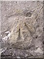
1
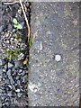
Ordnance Survey Rivet
This OS rivet can be found on the step of No55 Brondeg. It marks a point 71.150m above mean sea level.
Image: © Adrian Dust
Taken: 17 Jan 2014
0.19 miles
2
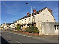
Pentregethin Road
Housing in Pentregethin Road, Cwmbwrla, Swansea.
Image: © Alan Hughes
Taken: 14 Feb 2019
0.20 miles
3
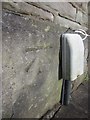
Ordnance Survey Cut Mark
This OS cut mark can be found on No242 Middle Road. It marks a point 94.134m above mean sea level.
Image: © Adrian Dust
Taken: 17 Jan 2014
0.22 miles
4
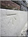
Ordnance Survey Cut Mark
This OS cut mark can be found on No173 Pentregethin Road. It marks a point 64.880m above mean sea level.
Image: © Adrian Dust
Taken: 15 Jan 2014
0.23 miles
5
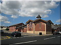
Eglwys Newydd. A New Church
Eglwys newydd Ffynnon Crist, diolch i'r aelod am ei ddiddordeb yn Geograff.
A new church called Christ Well, it's the Manselton United Reformed Church. Thanks to the congregation member for his information and interest in Geograph.
Image: © Gerallt Pennant
Taken: 18 Apr 2007
0.23 miles
6
Ordnance Survey Cut Mark
This damaged OS cut mark can be found on No171 Middle Road. It marks a point 77.721m above mean sea level.
Image: © Adrian Dust
Taken: 6 Jan 2014
0.24 miles