IMAGES TAKEN NEAR TO
Llangyfelach, SWANSEA, SA5 7PD
Introduction
This page details the photographs taken nearby to SA5 7PD by members of the Geograph project.
The Geograph project started in 2005 with the aim of publishing, organising and preserving representative images for every square kilometre of Great Britain, Ireland and the Isle of Man.

There are currently over 7.5m images from over14,400 individuals and you can help contribute to the project by visiting https://www.geograph.org.uk
Image Map
Images are licensed for reuse under creativecommons.org/licenses/by-sa/2.0
Notes
- Clicking on the map will re-center to the selected point.
- The higher the marker number, the further away the image location is from the centre of the postcode.
Image Listing (2 Images Found)
Images are licensed for reuse under creativecommons.org/licenses/by-sa/2.0
Image
Details
Distance
1
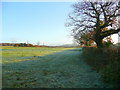
Pasture edge
With a view to Mynydd Gelliwastad (213m) in the distance.
Image: © Jonathan Billinger
Taken: 12 Nov 2008
0.23 miles
2
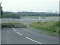
End of the road for British Steel Felindre Works
Felindre Road now stops at this point - where it used to run past British Steel Felindre Works on its right. The steel works has now been levelled and the road dug up to join the site to an adjacent one. A new road now leaves the nearby motorway junction from the south and joins on to the continued Felindre road on the far side of the levelled ground in the distance. This is what provides access to the small scale car park just visible in the distance.
In the past this site has hosted the Wales Rally GB in 2003 and then the National Eisteddfod in 2006.
Image: © Nigel Davies
Taken: 22 Sep 2008
0.25 miles