IMAGES TAKEN NEAR TO
Felindre, SWANSEA, SA5 7NQ
Introduction
This page details the photographs taken nearby to SA5 7NQ by members of the Geograph project.
The Geograph project started in 2005 with the aim of publishing, organising and preserving representative images for every square kilometre of Great Britain, Ireland and the Isle of Man.

There are currently over 7.5m images from over14,400 individuals and you can help contribute to the project by visiting https://www.geograph.org.uk
Image Map
Images are licensed for reuse under creativecommons.org/licenses/by-sa/2.0
Notes
- Clicking on the map will re-center to the selected point.
- The higher the marker number, the further away the image location is from the centre of the postcode.
Image Listing (2 Images Found)
Images are licensed for reuse under creativecommons.org/licenses/by-sa/2.0
Image
Details
Distance
1
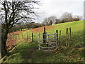
Llwybr y Bugail Path
Gât fochyn ar lwybr cyhoeddus sy'n cysylltu pentre Felindre â Chronfa Ddwr Lliw. Gelwir y ffordd hon yn Llwybr y Bugail ac mae Ffordd Gwyr hefyd yn ei chanlyn.
A kissing gate on a public footpath linking the village of Felindre with the Lower Lliw Reservoir. The path is known as Llwybr y Bugail (shepherds path) and the Gower Way also traverses this way.
Image: © Alan Richards
Taken: 4 Feb 2014
0.08 miles
2
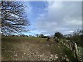
Animal feed point
Feeding area near Lletty Thomas.
Image: © Alan Hughes
Taken: 12 Feb 2020
0.13 miles