IMAGES TAKEN NEAR TO
Brynawel, SWANSEA, SA5 7LZ
Introduction
This page details the photographs taken nearby to Brynawel, SA5 7LZ by members of the Geograph project.
The Geograph project started in 2005 with the aim of publishing, organising and preserving representative images for every square kilometre of Great Britain, Ireland and the Isle of Man.

There are currently over 7.5m images from over14,400 individuals and you can help contribute to the project by visiting https://www.geograph.org.uk
Image Map
Images are licensed for reuse under creativecommons.org/licenses/by-sa/2.0
Notes
- Clicking on the map will re-center to the selected point.
- The higher the marker number, the further away the image location is from the centre of the postcode.
Image Listing (5 Images Found)
Images are licensed for reuse under creativecommons.org/licenses/by-sa/2.0
Image
Details
Distance
1
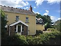
Coed Cae Croes
The map says 'Croes', the house name plate 'Groes'. Aaah - the mysteries of the Welsh soft mutation!
Image: © Alan Hughes
Taken: 4 Aug 2018
0.16 miles
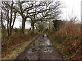
2
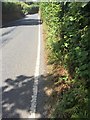
Hedgerow-lined road
Hedgerow lining the road to Felindre.
Image: © Alan Hughes
Taken: 4 Aug 2018
0.17 miles
3
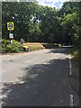
Felindre Road
Road from Felindre to M4 J46 through the Waun Ffyrdd plantation.
Image: © Alan Hughes
Taken: 4 Aug 2018
0.22 miles
4
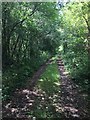
Cefnfforest Fawr
Woodland track to Cefnfforest Fawr.
Image: © Alan Hughes
Taken: 4 Aug 2018
0.22 miles
5
Trac Cefn y Fforest Track
Trac sy'n arwain o Goedwigoedd Penllergaer at heol fetel fach ger anhedd-dy Fforest Newydd. Mae'r trac hefyd yn rhoi mynediad i Ffarm Cefn y Fforest.
A track heading from Penllergaer Forest towards a minor road near a property known as Fforest Newydd (trans. new forest). The track is also an access road to Cefn y Fforest Farm (trans. forest ridge)
Image: © Alan Richards
Taken: 5 Mar 2014
0.24 miles