IMAGES TAKEN NEAR TO
Bryntywod, SWANSEA, SA5 7LF
Introduction
This page details the photographs taken nearby to Bryntywod, SA5 7LF by members of the Geograph project.
The Geograph project started in 2005 with the aim of publishing, organising and preserving representative images for every square kilometre of Great Britain, Ireland and the Isle of Man.

There are currently over 7.5m images from over14,400 individuals and you can help contribute to the project by visiting https://www.geograph.org.uk
Image Map
Images are licensed for reuse under creativecommons.org/licenses/by-sa/2.0
Notes
- Clicking on the map will re-center to the selected point.
- The higher the marker number, the further away the image location is from the centre of the postcode.
Image Listing (17 Images Found)
Images are licensed for reuse under creativecommons.org/licenses/by-sa/2.0
Image
Details
Distance
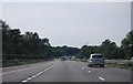
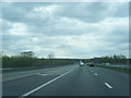
1
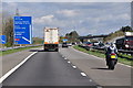
Swansea : M4 Motorway
The M4 Motorway heading eastbound through the Swansea area and approaching junction 46.
Image: © Lewis Clarke
Taken: 11 Apr 2014
0.07 miles
2
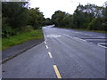
Bus Stop View
The view of the A48 near junction 46 of the M4.
Image: © Gordon Griffiths
Taken: 17 Sep 2011
0.08 miles
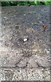
5
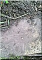
Ordnance Survey Rivet
This OS rivet can be found on the culvert south side of the road. It marks a point 76.971m above mean sea level.
Image: © Adrian Dust
Taken: 7 Jul 2021
0.11 miles
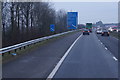
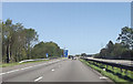
6
M4 slip road joins at Junction 46 westbound
Image: © Colin Pyle
Taken: 5 May 2012
0.12 miles
7
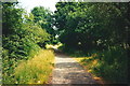
Heol y Geifr
Heol y Geifr, hen ffordd a arwain lan at eglwys a phentre Llangyfelach. Bu Ffair Llangyfelach a gynhelid ar y 1af o Fis Mawrth yn enwog iawn. Pentyrra pobl o bell ac agos iddi ac mae enw'r hewl o bosibl yn deillio o'r cyfnod hwnnw. Mae'r hewl eisioes wedi ei hisraddio i lwybr.
Heol y Geifr (trans. Goats Road) leading up the church and village of Llangyfelach (trans. Cyfelach's church). A famous fair, held annually on 1st March, was formerly held at Llangyfelach which drew people to it from far and wide and the naming of this road possibly derives from that period. The old thoroughfare has long been downgraded to a mere footpath.
Image: © Alan Richards
Taken: 15 Jul 1995
0.13 miles
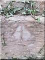
9
Ordnance Survey Rivet
This OS rivet can be found on the west parapet of Pont Llan. It marks a point 64.538m above mean sea level.
Image: © Adrian Dust
Taken: 7 Jul 2021
0.20 miles
10
Ordnance Survey Pivot
This OS pivot can be found on the south face of St David & St Cyfelach's Church. It marks a point 100.913m above mean sea level.
Image: © Adrian Dust
Taken: 9 Feb 2016
0.20 miles