IMAGES TAKEN NEAR TO
Pensalem Road, SWANSEA, SA5 7ED
Introduction
This page details the photographs taken nearby to Pensalem Road, SA5 7ED by members of the Geograph project.
The Geograph project started in 2005 with the aim of publishing, organising and preserving representative images for every square kilometre of Great Britain, Ireland and the Isle of Man.

There are currently over 7.5m images from over14,400 individuals and you can help contribute to the project by visiting https://www.geograph.org.uk
Image Map
Images are licensed for reuse under creativecommons.org/licenses/by-sa/2.0
Notes
- Clicking on the map will re-center to the selected point.
- The higher the marker number, the further away the image location is from the centre of the postcode.
Image Listing (3 Images Found)
Images are licensed for reuse under creativecommons.org/licenses/by-sa/2.0
Image
Details
Distance
1
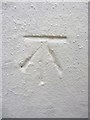
Ordnance Survey Cut Mark
This OS cut mark can be found on No2 Parkhill Terrace. It marks a point 107.021m above mean sea level.
Image: © Adrian Dust
Taken: 23 Jan 2014
0.14 miles
2
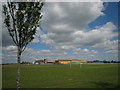
Ysgol a Chanolfan Hamdden. A School and Leisure Centre.
Adeilad arloesol.
A fine new building.
Image: © Gerallt Pennant
Taken: 18 Apr 2007
0.25 miles
3
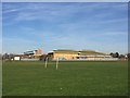
Penlan School
Playing fields at Penlan School.
Image: © Alan Hughes
Taken: 14 Feb 2019
0.25 miles