IMAGES TAKEN NEAR TO
Ozanam Court, SWANSEA, SA5 5JH
Introduction
This page details the photographs taken nearby to Ozanam Court, SA5 5JH by members of the Geograph project.
The Geograph project started in 2005 with the aim of publishing, organising and preserving representative images for every square kilometre of Great Britain, Ireland and the Isle of Man.

There are currently over 7.5m images from over14,400 individuals and you can help contribute to the project by visiting https://www.geograph.org.uk
Image Map
Images are licensed for reuse under creativecommons.org/licenses/by-sa/2.0
Notes
- Clicking on the map will re-center to the selected point.
- The higher the marker number, the further away the image location is from the centre of the postcode.
Image Listing (3 Images Found)
Images are licensed for reuse under creativecommons.org/licenses/by-sa/2.0
Image
Details
Distance
1
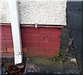
Ordnance Survey Cut Mark
This OS cut mark can be found on No39 Broughton Avenue. It marks a point 121.566m above mean sea level.
Image: © Adrian Dust
Taken: 18 Jan 2021
0.05 miles
2
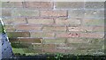
Ordnance Survey Cut Mark
This OS cut mark can be found on the NE angle of the school. It marks a point 135.191m above mean sea level.
Image: © Adrian Dust
Taken: 18 Jan 2021
0.17 miles
3

Pant Portmead / Portmead ravine
Pant sych yn Portmead lle llifai unwaith nant fach. Gelwir y llecyn hwn yn lleol yn 'The Ravine'. Ymddengys y pipwyd yr afonig pan adeiladwyd yr ystad nol yn y 1940au. Gerllaw y safai ffermydd Blaen y Maes a Pwllyrhwyad.
A dry hollow in Portmead where once a small stream flowed. Known locally as 'The Ravine' it appears that the stream was culverted when the housing estate was built probably after the 1940s. Nearby stood the farms of Blaen y Maes (trans. head of the field) and Pwllyrhwyad (trans. duck pond)
Image: © Alan Richards
Taken: 16 Mar 2014
0.20 miles