IMAGES TAKEN NEAR TO
Weig Fach Lane, SWANSEA, SA5 5AD
Introduction
This page details the photographs taken nearby to Weig Fach Lane, SA5 5AD by members of the Geograph project.
The Geograph project started in 2005 with the aim of publishing, organising and preserving representative images for every square kilometre of Great Britain, Ireland and the Isle of Man.

There are currently over 7.5m images from over14,400 individuals and you can help contribute to the project by visiting https://www.geograph.org.uk
Image Map
Images are licensed for reuse under creativecommons.org/licenses/by-sa/2.0
Notes
- Clicking on the map will re-center to the selected point.
- The higher the marker number, the further away the image location is from the centre of the postcode.
Image Listing (27 Images Found)
Images are licensed for reuse under creativecommons.org/licenses/by-sa/2.0
Image
Details
Distance
1
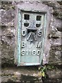
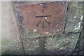
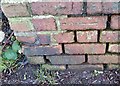
Ordnance Survey Flush Bracket (S1160)
This OS Flush Bracket can be found on a wall in front of Capel Calfaria. Now a nursery. It marks a point 317.550ft above mean sea level.
Image: © Adrian Dust
Taken: 20 Oct 2013
0.10 miles
2
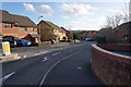
Clos Madlen
An infill housing development off Carmarthen Road.
Image: © Bill Boaden
Taken: 6 Apr 2016
0.14 miles
3
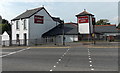
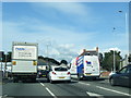
Marquis Arms, Swansea
Pub on the corner of Station Road and Carmarthen Road in the Fforestfach area of Swansea.
Image: © Jaggery
Taken: 25 Sep 2013
0.17 miles
4
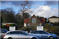
Gendros English Congregational Church (Evangelical)
Viewed across Carmarthen Road. The future of this building is in some doubt as it has maintenance issues, and a recent proposal has suggested it could become a Starbucks with the church continuing to meet in the hall at the back.
Image: © Bill Boaden
Taken: 6 Apr 2016
0.18 miles
6
Ordnance Survey Cut Mark
This OS cut mark can be found on the wall of the Kingdom Hall. It marks a point 96.792m above mean sea level.
Image: © Adrian Dust
Taken: 20 Jan 2019
0.19 miles
7
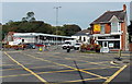
Totally Flabelos Swansea
Totally Flabelos is at 884 Carmarthen Road on the corner of Ravenhill Road.
The Flabelos system uses whole body vibration plate machines, derived from a technique that originated in Soviet space training centres to combat the effects of a gravity-free environment. Scientists discovered that vibration technology greatly extended the amount of time cosmonauts spent in space by increasing bone density, and maintaining muscle tissue.
A Ladbrokes betting shop is on the left side of Ravenhill Road.
Image: © Jaggery
Taken: 25 Sep 2013
0.19 miles
8
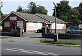
Kingdom Hall of Jehovah's Witnesses, Fforestfach, Swansea
Viewed across the A4216 Station Road. Jehovah's Witnesses use Kingdom Hall to describe their places of worship because the biblical use of "church" usually refers to the congregation of people rather than a structure.
Image: © Jaggery
Taken: 25 Sep 2013
0.20 miles
10
Ordnance Survey Cut Mark
This OS cut mark can be found on the wall NE side of Ravenhill Road. It marks a point 103.492m above mean sea level.
Image: © Adrian Dust
Taken: 20 Jan 2019
0.20 miles