IMAGES TAKEN NEAR TO
Hillbrook Close, SWANSEA, SA5 4QD
Introduction
This page details the photographs taken nearby to Hillbrook Close, SA5 4QD by members of the Geograph project.
The Geograph project started in 2005 with the aim of publishing, organising and preserving representative images for every square kilometre of Great Britain, Ireland and the Isle of Man.

There are currently over 7.5m images from over14,400 individuals and you can help contribute to the project by visiting https://www.geograph.org.uk
Image Map
Images are licensed for reuse under creativecommons.org/licenses/by-sa/2.0
Notes
- Clicking on the map will re-center to the selected point.
- The higher the marker number, the further away the image location is from the centre of the postcode.
Image Listing (16 Images Found)
Images are licensed for reuse under creativecommons.org/licenses/by-sa/2.0
Image
Details
Distance
1
Path on the edge of Gowerton
An area of expanding housing, and the route of the former railway has been interrupted by new development.
Image: © Bill Boaden
Taken: 6 Apr 2016
0.14 miles
2
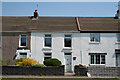
Cockett: Waunarlwydd Road
Terrace housing including Ty-Canol, centre
Image: © Martin Bodman
Taken: 8 Jun 2006
0.15 miles
3
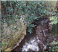
Gors-fawr Brook between Waunarlwydd and Gowerton
Viewed from the B4295, where the brook marks the boundary between Waunarlwydd to the east and Gowerton to the west.
Image: © Jaggery
Taken: 25 Sep 2013
0.17 miles
4
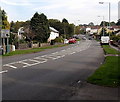
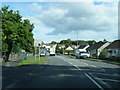
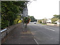
From Gowerton to Waunarlwydd
The B4295 from Gowerton passes the boundary sign for Waunarlwydd.
Image: © Jaggery
Taken: 25 Sep 2013
0.18 miles
5
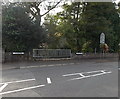
Bridge over Gors-fawr Brook between Waunarlwydd and Gowerton
The B4295 crosses the brook http://www.geograph.org.uk/photo/3673424 which here marks the boundary between Waunarlwydd and Gowerton. The Gowerton boundary sign is on the right.
Image: © Jaggery
Taken: 25 Sep 2013
0.18 miles
6
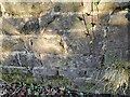
Ordnance Survey Cut Mark
This OS cut mark can be found on the NW buttress of the railway bridge. It marks a point 32.251m above mean sea level.
Image: © Adrian Dust
Taken: 14 Feb 2023
0.19 miles
7
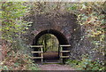
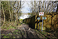
Accommodation arch near Gowerton
This bridge would have been built by the London and North Western Railway to carry its Swansea branch over a right of way. The railway closed in the 1960's and its route is now used for the Clyne Trail path.
Image: © john bristow
Taken: 25 Oct 2012
0.19 miles
8
SE boundary of Gowerton
On reaching Gowerton from Waunarlwydd, the B4295 Swansea Road is renamed the B4295 Gorwydd Road.
Image: © Jaggery
Taken: 25 Sep 2013
0.20 miles
9
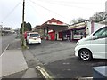
Garage on Bryn Road
Near the junction with Swansea Road, Waunarlwydd.
Image: © Alan Hughes
Taken: 20 Mar 2019
0.20 miles