IMAGES TAKEN NEAR TO
St. Nicholas Close, SWANSEA, SA5 4QB
Introduction
This page details the photographs taken nearby to St. Nicholas Close, SA5 4QB by members of the Geograph project.
The Geograph project started in 2005 with the aim of publishing, organising and preserving representative images for every square kilometre of Great Britain, Ireland and the Isle of Man.

There are currently over 7.5m images from over14,400 individuals and you can help contribute to the project by visiting https://www.geograph.org.uk
Image Map (13 Images)


Leaflet Map data © OpenStreetMap
Images are licensed for reuse under creativecommons.org/licenses/by-sa/2.0
Notes
- Clicking on the map will re-center to the selected point.
- The higher the marker number, the further away the image location is from the centre of the postcode.
Image Listing (13 Images Found)
Images are licensed for reuse under creativecommons.org/licenses/by-sa/2.0
Image
Details
Distance
1
Waunarlwydd footpath to former mine
This straight path runs directly south from Westwinds Close to the former mine. A local told me it is the route of an old rail line over to the Alcoa metal works to the north.
Although the finger post shows it is a public footpath it is not marked as such on any OS map.
Image: © Nigel Davies
Taken: 16 Nov 2008
0.11 miles
2
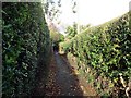
Llwybr Waunarlwydd Path
Llwybr cyhoeddus yn Waunarlwydd sy'n cysylltu Heol Victoria â Heol Abertawe.
A public footpath in Waunarlwydd < Waunarglwydd (trans. lord's moor) linking Victoria Road with Swansea Road.
Image: © Alan Richards
Taken: 16 Jan 2015
0.13 miles
3
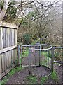
Footpath at Caergynydd Fawr
Kissing gate on footpath.
Image: © Alan Hughes
Taken: 20 Mar 2019
0.14 miles
4

Bethany chapel, Waunarlwydd
Viewed across Bryn Road. Bethany English Baptist chapel dates from 1875. The English part of its name referred to the language of worship, to distinguish it from chapels where Welsh was used.
Image: © Jaggery
Taken: 25 Sep 2013
0.18 miles
5
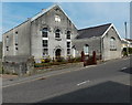
Sardis Chapel, Waunarlwydd
Viewed across Swansea Road. The graveyard at the back of the chapel is long and narrow (100 metres by 15 metres). The chapel dates from 1860.
Image: © Jaggery
Taken: 25 Sep 2013
0.19 miles
6
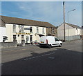
Farmers Arms Waunarlwydd
Pub at 284 Swansea Road.
Image: © Jaggery
Taken: 25 Sep 2013
0.19 miles
7
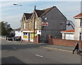
Azeem General Store, Waunarlwydd
Viewed across Swansea Road.
Image: © Jaggery
Taken: 25 Sep 2013
0.20 miles
8
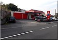
Murco filling station and shop, Waunarlwydd
Viewed across the B4295 Bryn Road near the point where it becomes the B4295 Swansea Road.
Image: © Jaggery
Taken: 25 Sep 2013
0.21 miles

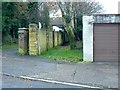
10
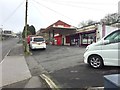
Garage on Bryn Road
Near the junction with Swansea Road, Waunarlwydd.
Image: © Alan Hughes
Taken: 20 Mar 2019
0.21 miles