IMAGES TAKEN NEAR TO
Waunarlwydd, SWANSEA, SA5 4NJ
Introduction
This page details the photographs taken nearby to SA5 4NJ by members of the Geograph project.
The Geograph project started in 2005 with the aim of publishing, organising and preserving representative images for every square kilometre of Great Britain, Ireland and the Isle of Man.

There are currently over 7.5m images from over14,400 individuals and you can help contribute to the project by visiting https://www.geograph.org.uk
Image Map
Images are licensed for reuse under creativecommons.org/licenses/by-sa/2.0
Notes
- Clicking on the map will re-center to the selected point.
- The higher the marker number, the further away the image location is from the centre of the postcode.
Image Listing (18 Images Found)
Images are licensed for reuse under creativecommons.org/licenses/by-sa/2.0
Image
Details
Distance
1
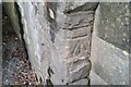
Ordnance Survey Cut Mark
This OS cut mark can be found on the east buttress of the railway bridge on Roseland Road. It marks a point 34.607m above mean sea level.
Image: © Adrian Dust
Taken: 5 Jan 2021
0.12 miles
2
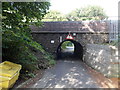
6' 3" headroom under Roseland Road railway bridge, Waunarlwydd
Roseland Road passes under the West Wales Line railway. The headroom is less than 2 metres (6' 3" is 1.905 metres).
Image: © Jaggery
Taken: 25 Sep 2013
0.12 miles
3
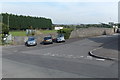
Roseland Road, Waunarlwydd
Roseland Road descends from Swansea Road towards this http://www.geograph.org.uk/photo/3672409 low railway bridge.
Image: © Jaggery
Taken: 25 Sep 2013
0.13 miles
4
School access road in Waunarlwydd
Viewed across Roseland Road. The unnamed road heads past the southern edge of a rugby ground, towards Ysgol Gynradd Gymraeg Y Login Fach, a bilingual (Welsh and English) primary school.
Image: © Jaggery
Taken: 25 Sep 2013
0.13 miles
5
Rosewarne Close, Waunarlwydd
Rosewarne Close extends for 120 metres on the north side of the B4295 Swansea Road.
Image: © Jaggery
Taken: 25 Sep 2013
0.15 miles
6
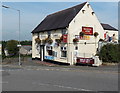
Masons Arms Waunarlwydd
Pub on the corner of Swansea Road and Roseland Road.
Image: © Jaggery
Taken: 25 Sep 2013
0.19 miles
7

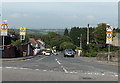
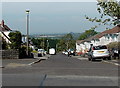
North along Swansea Road, Waunarlwydd
The B4295 runs left to right in the foreground. It is named Swansea Road on the right, Victoria Road on the left. Swansea Road continues ahead as an unclassified road.
Image: © Jaggery
Taken: 25 Sep 2013
0.19 miles
8
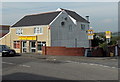
Eastern Kitchen, Waunarlwydd
Chinese takeaway at 110 Swansea Road on the corner of Roseland Road
opposite the Masons Arms. http://www.geograph.org.uk/photo/3672392
Image: © Jaggery
Taken: 25 Sep 2013
0.20 miles
9

Clas-y-Bedw flats in Waunarlwydd
Set back from the north side of the B4295 Swansea Road.
Image: © Jaggery
Taken: 25 Sep 2013
0.20 miles
10
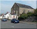
Zion Welsh Baptist Chapel, Waunarlwydd
Zion Chapel (Capel Seion in Welsh) is on the east side of Swansea Road. The chapel dates from 1860.
Image: © Jaggery
Taken: 25 Sep 2013
0.21 miles