IMAGES TAKEN NEAR TO
Ystrad Road, SWANSEA, SA5 4NE
Introduction
This page details the photographs taken nearby to Ystrad Road, SA5 4NE by members of the Geograph project.
The Geograph project started in 2005 with the aim of publishing, organising and preserving representative images for every square kilometre of Great Britain, Ireland and the Isle of Man.

There are currently over 7.5m images from over14,400 individuals and you can help contribute to the project by visiting https://www.geograph.org.uk
Image Map
Images are licensed for reuse under creativecommons.org/licenses/by-sa/2.0
Notes
- Clicking on the map will re-center to the selected point.
- The higher the marker number, the further away the image location is from the centre of the postcode.
Image Listing (8 Images Found)
Images are licensed for reuse under creativecommons.org/licenses/by-sa/2.0
Image
Details
Distance
1
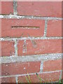
Ordnance Survey Cut Mark
This OS cut mark can be found on the Home Comforts Care building. It marks a point 32.964m above mean sea level.
Image: © Adrian Dust
Taken: 9 Jul 2014
0.05 miles
2
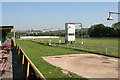
Cockett Community: greyhound stadium near Mynydd-bach-y-glo
Looking north-north-west
Image: © Martin Bodman
Taken: 9 Jun 2006
0.10 miles
3
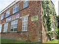
Fit2Fight Academy
There is an Ordnance Survey cut mark on the corner of the building. http://www.geograph.org.uk/photo/4065083
Image: © Adrian Dust
Taken: 9 Jul 2014
0.12 miles
4
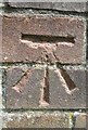
Ordnance Survey Cut Mark
This OS cut mark can be found on the corner of Fit2Fight. It marks a point 32.327m above mean sea level. http://www.geograph.org.uk/photo/4064976
Image: © Adrian Dust
Taken: 9 Jul 2014
0.12 miles
5
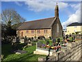
St.Illtyd's Church
Church in Ystrad Road Fforestfach.
Image: © Alan Hughes
Taken: 5 Nov 2017
0.20 miles
6

BKS Studios
There is an Ordnance Survey cut mark on the south angle. http://www.geograph.org.uk/photo/4065105
Image: © Adrian Dust
Taken: 9 Jul 2014
0.20 miles
7
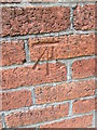
Ordnance Survey Cut Mark
This OS cut mark can be found on the corner of BKS. It marks a point 38.944m above mean sea level. http://www.geograph.org.uk/photo/4065109
Image: © Adrian Dust
Taken: 9 Jul 2014
0.21 miles
8
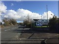
Fforestfach industrial estate
Road through the Fforestfach industrial estate.
Image: © Alan Hughes
Taken: 5 Nov 2017
0.21 miles