IMAGES TAKEN NEAR TO
Oak Way, SWANSEA, SA4 9WW
Introduction
This page details the photographs taken nearby to Oak Way, SA4 9WW by members of the Geograph project.
The Geograph project started in 2005 with the aim of publishing, organising and preserving representative images for every square kilometre of Great Britain, Ireland and the Isle of Man.

There are currently over 7.5m images from over14,400 individuals and you can help contribute to the project by visiting https://www.geograph.org.uk
Image Map (Loading...)


Getting Data...Please wait
Leaflet Map data © OpenStreetMap
Images are licensed for reuse under creativecommons.org/licenses/by-sa/2.0
Notes
- Clicking on the map will re-center to the selected point.
- The higher the marker number, the further away the image location is from the centre of the postcode.
Image Listing (20 Images Found)
Images are licensed for reuse under creativecommons.org/licenses/by-sa/2.0
Image
Details
Distance
1
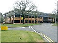
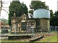
Council Offices, Penllergare wood, Swansea
These offices were originally for Lliw Borough but became part of Swansea council at local government reorganisation.
The offices are built on the site of the original mansion house at Penllergare estate. The house was demolished in 1961 after being ruined in the war - not by German bombs like most of Swansea, but by allied soldiers who were accommodated here.
Image: © Nigel Davies
Taken: 21 Mar 2010
0.10 miles
2
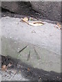
Ordnance Survey Rivet
This OS rivet can be found on the steps to the west of the drive. It marks a point 74.521m above mean sea level. http://www.geograph.org.uk/photo/4103443
Image: © Adrian Dust
Taken: 3 Aug 2014
0.11 miles
3
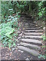
Steps, Penllergare
To the west of the Carriage Drive. There is an Ordnance Survey Rivet on the second step. http://www.geograph.org.uk/photo/4103440
Image: © Adrian Dust
Taken: 3 Aug 2014
0.11 miles
4
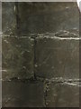
Ordnance Survey Cut Mark
This OS cut mark can be found on the Equatorial Observatory Ruin. Where John Dillwyn Llewelyn took one of the first photographs of the moon.
Image: © Adrian Dust
Taken: 3 Aug 2014
0.12 miles
5
Observatory at former Penllergare Estate
The observatory was built in 1851 by John Dillwyn Llewelyn. It was adjacent to the mansion house which has since been demolished and replaced by council offices.
See:
http://www.penllergare.org/html/timeline.html
http://en.wikipedia.org/wiki/John_Dillwyn_Llewelyn
http://www.swanseaheritage.net/article/gat.asp?ARTICLE_ID=1392
Image: © Nigel Davies
Taken: 21 Mar 2010
0.12 miles
6
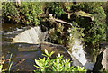
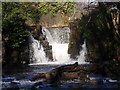
The upstream edge of the Penllergare waterfall
The fall has been wonderfully constructed to show the drama of falling water.
Image: © john bristow
Taken: 6 Oct 2012
0.14 miles
7
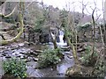
Waterfall in Penllergare Valley Wood
A man made lake lies behind the waterfalls. This appears to be a dam - but closer inspection seems that it's a combination of man made and natural features.
Image: © Hywel Williams
Taken: 3 Jan 2011
0.14 miles
8
The Penllergare Estate waterfall
The location of this feature in the middle of tranquil woodland is very dramatic.
Image: © john bristow
Taken: 6 Oct 2012
0.14 miles
9
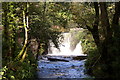
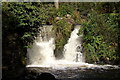
Sgwd Penllergaer Waterfall
Lleolir y sgwd ysblenydd hwn yng Nghoed Penllergaer ger Abertawe. Sgwd artiffisial ydyw a adeiladwyd gan John Dillwyn Llewelyn (1810 - 1882), sgwier Plas Penllergaer, oddeutu 1839 fel ran o'i gynllun i wella harddwch ei ystad. Ceir hefyd bysgodlyn y tu ol i'r sgwd. 'Llan' yw enw'r afon ond ei hen enw oedd Lliw Eithaf (mae'r enw wedi goroesi ym mhentref cyfagos [Pont] Llewitha). Ar ol blynyddau o esgeulustod mae'r ystad bellach yn cael ei gofalu gan Ymddiriedolaeth Penllergaer
This splendid waterfall is located in Penllergaer Woods near Swansea. It is an artificial waterfall built c1839 by John Dillwyn Llewelyn (1810-1882) squire of Penllergaer Mansion, to enhance the beauty of his estate. A fishpond is located immediately behind the falls. 'Llan' is the name of the river but its old name 'Lliw Eithaf' has survived as that of the nearby village of [Pont] Llewitha. After years of neglect the estate is now being cared for by the Penllergaer Trust.
Image: © Alan Richards
Taken: 28 Jan 2012
0.15 miles
10
The Penllergare waterfall
Following periods of heavy rain the fall was in full spate.
Image: © john bristow
Taken: 6 Oct 2012
0.15 miles