IMAGES TAKEN NEAR TO
Llyn Tircoed, SWANSEA, SA4 9LB
Introduction
This page details the photographs taken nearby to Llyn Tircoed, SA4 9LB by members of the Geograph project.
The Geograph project started in 2005 with the aim of publishing, organising and preserving representative images for every square kilometre of Great Britain, Ireland and the Isle of Man.

There are currently over 7.5m images from over14,400 individuals and you can help contribute to the project by visiting https://www.geograph.org.uk
Image Map (Loading...)


Getting Data...Please wait
Leaflet Map data © OpenStreetMap
Images are licensed for reuse under creativecommons.org/licenses/by-sa/2.0
Notes
- Clicking on the map will re-center to the selected point.
- The higher the marker number, the further away the image location is from the centre of the postcode.
Image Listing (36 Images Found)
Images are licensed for reuse under creativecommons.org/licenses/by-sa/2.0
Image
Details
Distance
1
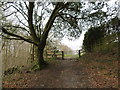
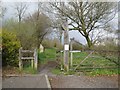
Llwybr Tircoed Path
Llwybr yn agosau at ystad Tircoed.
A path approaching the Tircoed Estate (trans. woodland).
Image: © Alan Richards
Taken: 5 Mar 2014
0.08 miles
2
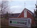
Radio Tircoed studios
Behind the modern community centre for the newly built Tircoed housing estate are what appear to be two shipping containers. Their livery reveals that they are in fact the studios for Radio Tircoed which commenced broadcasting on 1st December 2008.
The station is self funded and is entirely run by volunteers and serves the communities of Tircoed, Penllergaer, Pontardulais, Gorseinon, Pontlliw and the M4 Corridor between junctions 47 and 48 - though the signal can be clearly heard much further.
Along with its relatively powerful (for a community radio station) FM signal, the station also broadcasts on the internet on its web site, and DJs now frequently get requests from all over the world as well as the community in which it serves.
This was the original studio facility - it has since been replaced by a substantially larger structure.
Image: © Hywel Williams
Taken: 24 Dec 2008
0.09 miles
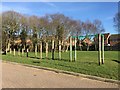
4
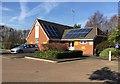
Tircoed Community Centre
Tircoed is a large modern housing estate built in Penllergaer Forest over the last few years. Much thought has been given to the estate (though the layout can be confusing if you don't know your way round) - it includes its own convenience store and a modern community centre.
A recent addition to this building is the antenna attached to the back of the building. This is a quarter wave transmitter mast for the recently launched Radio Tircoed, a voluntary run community radio station.
Image: © Hywel Williams
Taken: 24 Dec 2008
0.13 miles
5
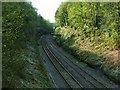
Penllergaer railway cutting
This section of railway cutting at Penllergaer is a SSSI due to the rare strata of rock it has exposed. The CCW documents suggest that the strata should be kept exposed by removing vegetation and scree. Railtrack do not seem to concur.
See also http://www.ccw.gov.uk/landscape--wildlife/protecting-our-landscape/special-landscapes--sites/protected-landscapes-and-sites/sssis/sssi-sites/penllergaer-railway-cutting.aspx
Image: © Nigel Davies
Taken: 5 May 2013
0.13 miles
6
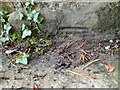
Ordnance Survey Cut Mark
This mostly buried OS cut mark can be found on the SW parapet of the railway bridge. It marks a point 62.868m above mean sea level.
Image: © Adrian Dust
Taken: 29 Sep 2022
0.14 miles
7
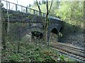
Footbridge over railway at Penllergaer
This bridge is now part of a footpath from Penllergaer Forest carpark Image to Tircoed village Image I'd imagine it pre-dates the village and was originally part of a farm track.
The bridge also supports a pipe which carries a small stream across the railway cutting.
Image: © Nigel Davies
Taken: 5 May 2013
0.14 miles
8
Tircoed Village Hall - Radio Tircoed
Radio Tircoed - community radio station.
Image: © Alan Hughes
Taken: 14 Feb 2019
0.15 miles
9
Northeast entrance from Tircoed village into Penllergaer Forest
The gate off the street Brynhyfryd into Forestry Commission land.
Image: © Nigel Davies
Taken: 27 Apr 2013
0.16 miles
10
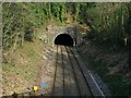
West portal of Penllergaer rail tunnel
As seen from the nearby footbridge Image
Image: © Nigel Davies
Taken: 5 May 2013
0.18 miles