IMAGES TAKEN NEAR TO
Clordir Road, SWANSEA, SA4 9FA
Introduction
This page details the photographs taken nearby to Clordir Road, SA4 9FA by members of the Geograph project.
The Geograph project started in 2005 with the aim of publishing, organising and preserving representative images for every square kilometre of Great Britain, Ireland and the Isle of Man.

There are currently over 7.5m images from over14,400 individuals and you can help contribute to the project by visiting https://www.geograph.org.uk
Image Map
Images are licensed for reuse under creativecommons.org/licenses/by-sa/2.0
Notes
- Clicking on the map will re-center to the selected point.
- The higher the marker number, the further away the image location is from the centre of the postcode.
Image Listing (46 Images Found)
Images are licensed for reuse under creativecommons.org/licenses/by-sa/2.0
Image
Details
Distance
1
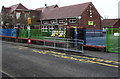
Pontlliw Primary School
Viewed across Clordir Road in Pontlliw.
Image: © Jaggery
Taken: 14 Feb 2015
0.01 miles
2
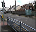
East along Clordir Road, Pontlliw
Viewed from the corner of the A48. Pontlliw Primary School http://www.geograph.org.uk/photo/4350840 is ahead on the left.
Image: © Jaggery
Taken: 14 Feb 2015
0.03 miles
3

Welcome in nine languages, Pontlliw
On a gate on the Clordir Road side of Pontlliw Primary School http://www.geograph.org.uk/photo/4350840
Image: © Jaggery
Taken: 14 Feb 2015
0.03 miles
4
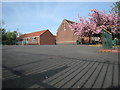
Ysgol Pontlliw. Pontlliw School.
Ysgol y pentref.
The village school.
Image: © Gerallt Pennant
Taken: 17 Apr 2007
0.03 miles
5
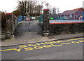
Stop parking on our zigzags!, Pontlliw
The banner is on railings at the Clordir Road side of Pontlliw Primary School.
Yellow text painted on the road surface shows SCHOOL - KEEP CLEAR and its Welsh equivalent.
Image: © Jaggery
Taken: 14 Feb 2015
0.03 miles
6
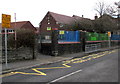
Main entrance to Pontlliw Primary School
From Clordir Road near the A48 junction in Pontlliw.
Image: © Jaggery
Taken: 14 Feb 2015
0.04 miles
7
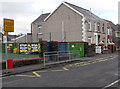
Bilingual No Stopping sign outside Pontlliw Primary School
Viewed across Clordir Road in Pontlliw. No Stopping is Dim Stopio in Welsh.
Image: © Jaggery
Taken: 14 Feb 2015
0.04 miles
8

Pontlliw: postbox № SA4 509, Swansea Road
This Elizabeth II-reign postbox stands outside Image and is emptied finally at 5:30pm on weekdays and at 12:15pm on Saturdays.
Image: © Chris Downer
Taken: 17 Aug 2010
0.05 miles
9
Clordir Road pelican crossing and electricity substation in Pontlliw
Located near the A48 junction. A pelican crossing is the type of pedestrian-operated street crossing seen here. Chambers Dictionary states that "pelican" is adapted from "pedestrian light controlled crossing".
The identifier on the Western Power Distribution electricity substation behind the traffic light is
CLORDIR ROAD PONTLLIW S/S 524433.
Image: © Jaggery
Taken: 14 Feb 2015
0.05 miles
10

Pontlliw: the post office/stores
An ironic local news headline is on display outside the village stores and post office.
Image: © Chris Downer
Taken: 17 Aug 2010
0.06 miles