IMAGES TAKEN NEAR TO
Heol Y Twyn, SWANSEA, SA4 9EU
Introduction
This page details the photographs taken nearby to Heol Y Twyn, SA4 9EU by members of the Geograph project.
The Geograph project started in 2005 with the aim of publishing, organising and preserving representative images for every square kilometre of Great Britain, Ireland and the Isle of Man.

There are currently over 7.5m images from over14,400 individuals and you can help contribute to the project by visiting https://www.geograph.org.uk
Image Map
Images are licensed for reuse under creativecommons.org/licenses/by-sa/2.0
Notes
- Clicking on the map will re-center to the selected point.
- The higher the marker number, the further away the image location is from the centre of the postcode.
Image Listing (48 Images Found)
Images are licensed for reuse under creativecommons.org/licenses/by-sa/2.0
Image
Details
Distance
1
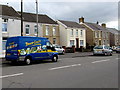
Trevor Lewis Signs van in Pontlliw
Parked in Swansea Road. Text on the van states that a business with no sign is a sign of no business.
Image: © Jaggery
Taken: 14 Feb 2015
0.05 miles
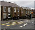
2

Pontlliw Post Office
Post Office and General Stores, Swansea Road, Pontlliw.
Image: © Alan Hughes
Taken: 19 Nov 2018
0.06 miles
3
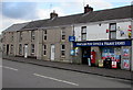
Pontlliw Post Office & Village Stores
Viewed across the A48 Swansea Road.
Image: © Jaggery
Taken: 14 Feb 2015
0.06 miles
4
Loops of barbed wire on a field gate, Pontlliw
On the north side of Carmel Road.
Image: © Jaggery
Taken: 14 Feb 2015
0.06 miles
5
Relic of Bethania preserved opposite Carmel Baptist Church, Pontlliw
Embedded in the wall opposite Carmel http://www.geograph.org.uk/photo/4349523 is a tablet showing BETHANIA. Bethania Chapel opened in Grovesend in 1908. After it closed down in 1993, the remaining members of Bethania worshipped at Carmel.
Image: © Jaggery
Taken: 14 Feb 2015
0.06 miles
6

Pontlliw: the post office/stores
An ironic local news headline is on display outside the village stores and post office.
Image: © Chris Downer
Taken: 17 Aug 2010
0.07 miles
7
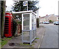
Phonebox and bus shelter in Pontlliw
Alongside the A48 Swansea Road.
Image: © Jaggery
Taken: 14 Feb 2015
0.07 miles
8
SLOW on the A48 Swansea Road, Pontlliw
SLOW and its Welsh equivalent ARAF are on the approach to a bend to the left.
The yellow back of a speed camera http://www.geograph.org.uk/photo/4347763 is on the right.
Image: © Jaggery
Taken: 14 Feb 2015
0.07 miles
9
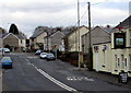
Swansea Road, Pontlliw
The A48 Swansea Road is the main road through the village. A small part of the Castle Inn http://www.geograph.org.uk/photo/4347886 is on the right.
Image: © Jaggery
Taken: 14 Feb 2015
0.07 miles
10
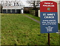
St Anne's Church, Pontlliw
Set back 50 metres from the east side of the A48 Swansea Road. Erected in 1909 as a mission hall to serve the religious needs of railway construction workers most of whom were English and therefore could not understand the local Welsh language chapel services. In 2015, the building is St Anne's Church in the Church in Wales Parish of Penllergaer , Diocese of Swansea & Brecon.
Image: © Jaggery
Taken: 14 Feb 2015
0.07 miles