IMAGES TAKEN NEAR TO
Broadwood, SWANSEA, SA4 9DH
Introduction
This page details the photographs taken nearby to Broadwood, SA4 9DH by members of the Geograph project.
The Geograph project started in 2005 with the aim of publishing, organising and preserving representative images for every square kilometre of Great Britain, Ireland and the Isle of Man.

There are currently over 7.5m images from over14,400 individuals and you can help contribute to the project by visiting https://www.geograph.org.uk
Image Map (Loading...)


Getting Data...Please wait
Leaflet Map data © OpenStreetMap
Images are licensed for reuse under creativecommons.org/licenses/by-sa/2.0
Notes
- Clicking on the map will re-center to the selected point.
- The higher the marker number, the further away the image location is from the centre of the postcode.
Image Listing (4 Images Found)
Images are licensed for reuse under creativecommons.org/licenses/by-sa/2.0
Image
Details
Distance
2
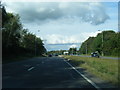
Layby on A483
Layby and traffic on the A483 at Penllergaer.
Image: © Alan Hughes
Taken: 20 Nov 2017
0.22 miles
3

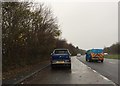
Old Swansea Road from Penllergaer
Now an abandoned road, technically a dead end (though if you're brave enough and are willing to get your car covered in mud just beyond the trees in the distance, still a through road). Close examination reveals that this was once a main road into Swansea - now it's left abandoned for the weeds to slowly grow over.
Image: © Hywel Williams
Taken: 24 Apr 2009
0.22 miles
4
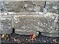
Ordnance Survey Cut Mark
This OS cut mark can be found on the wall of No38 Swansea Road. It marks a point 100.551m above mean sea level.
Image: © Adrian Dust
Taken: 7 Jul 2021
0.24 miles