IMAGES TAKEN NEAR TO
Clos Bryn Dafydd, SWANSEA, SA4 9BX
Introduction
This page details the photographs taken nearby to Clos Bryn Dafydd, SA4 9BX by members of the Geograph project.
The Geograph project started in 2005 with the aim of publishing, organising and preserving representative images for every square kilometre of Great Britain, Ireland and the Isle of Man.

There are currently over 7.5m images from over14,400 individuals and you can help contribute to the project by visiting https://www.geograph.org.uk
Image Map (Loading...)


Getting Data...Please wait
Leaflet Map data © OpenStreetMap
Images are licensed for reuse under creativecommons.org/licenses/by-sa/2.0
Notes
- Clicking on the map will re-center to the selected point.
- The higher the marker number, the further away the image location is from the centre of the postcode.
Image Listing (12 Images Found)
Images are licensed for reuse under creativecommons.org/licenses/by-sa/2.0
Image
Details
Distance
1
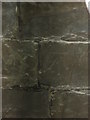
Ordnance Survey Cut Mark
This OS cut mark can be found on the Equatorial Observatory Ruin. Where John Dillwyn Llewelyn took one of the first photographs of the moon.
Image: © Adrian Dust
Taken: 3 Aug 2014
0.13 miles
2
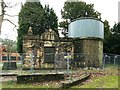
Observatory at former Penllergare Estate
The observatory was built in 1851 by John Dillwyn Llewelyn. It was adjacent to the mansion house which has since been demolished and replaced by council offices.
See:
http://www.penllergare.org/html/timeline.html
http://en.wikipedia.org/wiki/John_Dillwyn_Llewelyn
http://www.swanseaheritage.net/article/gat.asp?ARTICLE_ID=1392
Image: © Nigel Davies
Taken: 21 Mar 2010
0.14 miles
3
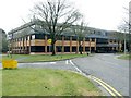
Council Offices, Penllergare wood, Swansea
These offices were originally for Lliw Borough but became part of Swansea council at local government reorganisation.
The offices are built on the site of the original mansion house at Penllergare estate. The house was demolished in 1961 after being ruined in the war - not by German bombs like most of Swansea, but by allied soldiers who were accommodated here.
Image: © Nigel Davies
Taken: 21 Mar 2010
0.15 miles
4
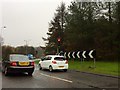
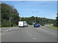
Traffic at roundabout
Traffic on the roundabout junction of the A483 and M4.
Image: © Alan Hughes
Taken: 20 Nov 2017
0.20 miles
5
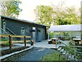
Coffee Shop in Penllergare Valley Woods
The woods project has a new pay and display car park. This coffee shop is just beside it.
Image: © Nigel Davies
Taken: 23 Aug 2014
0.22 miles
7
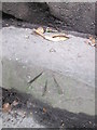
Ordnance Survey Rivet
This OS rivet can be found on the steps to the west of the drive. It marks a point 74.521m above mean sea level. http://www.geograph.org.uk/photo/4103443
Image: © Adrian Dust
Taken: 3 Aug 2014
0.22 miles
8
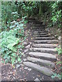
Steps, Penllergare
To the west of the Carriage Drive. There is an Ordnance Survey Rivet on the second step. http://www.geograph.org.uk/photo/4103440
Image: © Adrian Dust
Taken: 3 Aug 2014
0.22 miles
9
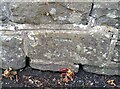
Ordnance Survey Cut Mark
This OS cut mark can be found on the wall of No38 Swansea Road. It marks a point 100.551m above mean sea level.
Image: © Adrian Dust
Taken: 7 Jul 2021
0.22 miles
10
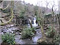
Waterfall in Penllergare Valley Wood
A man made lake lies behind the waterfalls. This appears to be a dam - but closer inspection seems that it's a combination of man made and natural features.
Image: © Hywel Williams
Taken: 3 Jan 2011
0.24 miles