IMAGES TAKEN NEAR TO
Station Road, SWANSEA, SA4 8TJ
Introduction
This page details the photographs taken nearby to Station Road, SA4 8TJ by members of the Geograph project.
The Geograph project started in 2005 with the aim of publishing, organising and preserving representative images for every square kilometre of Great Britain, Ireland and the Isle of Man.

There are currently over 7.5m images from over14,400 individuals and you can help contribute to the project by visiting https://www.geograph.org.uk
Image Map
Images are licensed for reuse under creativecommons.org/licenses/by-sa/2.0
Notes
- Clicking on the map will re-center to the selected point.
- The higher the marker number, the further away the image location is from the centre of the postcode.
Image Listing (97 Images Found)
Images are licensed for reuse under creativecommons.org/licenses/by-sa/2.0
Image
Details
Distance
1

Village Pharmacy, Pontarddulais
Viewed from Pontarddulais railway station access road, on the east bank of the River Loughor.
Image: © Jaggery
Taken: 11 Feb 2015
0.02 miles
2

MOT centre in a former railway building near Pontarddulais railway station
Located on the east bank of the River Loughor,
viewed from the Pontarddulais railway station access road.
Image: © Jaggery
Taken: 11 Feb 2015
0.02 miles
3
Pontarddulais railway station, Carmarthenshire
Opened as "Pontardulais" in 1850 by the "Llanelly" Railway, later part of the Great Western Railway, on the line from Llanelli to Llandeilo, the spelling was changed in 1980.
All the old buildings have now been swept away and four platforms reduced to one, as the station is no longer a junction. The only building remaining from an earlier age is the former goods shed.
Image: © Nigel Thompson
Taken: 17 May 2014
0.02 miles
4
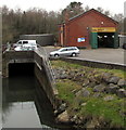
MOT garage on a riverbank, Pontarddulais
On the east bank of the River Loughor.
Image: © Jaggery
Taken: 11 Feb 2015
0.02 miles
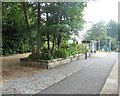
5

Railway station access road, Pontarddulais
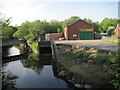
Extending along the east bank of the River Loughor from the A48 behind the camera to the station entrance 80 metres ahead. A former railway building is on the left. http://www.geograph.org.uk/photo/4360428 Village Pharmacy http://www.geograph.org.uk/photo/4360424 is on the right.
Image: © Jaggery
Taken: 11 Feb 2015
0.02 miles
6
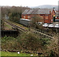
Heart of Wales line towards Pontarddulais railway station
The single-track line crosses the river bridge seen on the left here http://www.geograph.org.uk/photo/4415823
A former railway brick building is now a garage.
Pontarddulais railway station shelter is in the background on the left.
Image: © Jaggery
Taken: 11 Feb 2015
0.02 miles
7
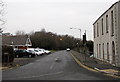
North along Station Road, Pontarddulais
Viewed across the A48. Station Road leads to Pontarddulais Industrial Estate and Workshops.
Pontarddulais railway station is nearby.
Image: © Jaggery
Taken: 11 Feb 2015
0.03 miles
9
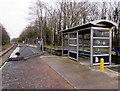
Pontarddulais railway station shelter
The facilities on this single-platform station on the Heart of Wales Line are a passenger shelter and ....
nothing else. No toilets.
Image: © Jaggery
Taken: 11 Feb 2015
0.03 miles
10
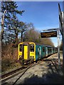
Pontarddulais station
Train arriving at Pontarddulais railway station.
Image: © Alan Hughes
Taken: 14 Feb 2019
0.03 miles