1
Unsung Heroes
Something these guys deal with every day, a small scrub fire near some factories - yet the Fire Service around the UK have saved countless lives over the years.
One moment he's putting out a small accidental fire - then within an hour, without warning he may well be risking his own life without a thought, to save another.
Image: © Hywel Williams
Taken: 6 Jun 2008
0.05 miles
2
Parc Coed Bach
Municipal park on the flood plain of the Afon Llwchwr, with a rugby pitch visible beyond.
Image: © Marion Phillips
Taken: 22 Jul 2009
0.11 miles
3
Changed Shopping Experience in April 2020
Just a small example of how every day life changed UTTERLY in March/April 2020 due to the CoVid-19 Coronavirus) pandemic. Just a month ago, shopping in Tesco was an every day routine. You went in, you bought your stuff and you left. You didn't think any more about it.
Just a month later, you have to queue for around 10 minutes with tape, signs and notices everywhere telling you to keep 2 metres apart. Large swathes of car park are now closed to allow people more space to get into the queue. People are being let in to the supermarket on a one in, one out (and even couples aren't allowed to shop together). There's a cleaning station to disinfect the shopping trolley (though I have my doubts about how effective this is).
Even inside, it's an utterly surreal experience of taped off floors where only one person is allowed in each "segment" at a time.
And of course, the entire public is now almost on "house arrest" and unable to go out and about taking pictures and enjoying the countryside as we were able to do, just a month ago.
Image: © Hywel Williams
Taken: 9 Apr 2020
0.12 miles
4
The "New normal" of shopping during the 2020 Covid-19 pandemic
Since the Covid-19 outbreak of 2020 started - this is the new "normal" of supermarket shopping to allow social isolation. Closed car parks to allow people to get into the queue with at least 2 metres between each individual, and queues extending around the entire car park just to get into the supermarket lasting at least 30 minutes at times.
At this moment in time - gone are the times you could just pop down the supermarket for a quick shop...
Image: © Hywel Williams
Taken: 8 May 2020
0.12 miles
5
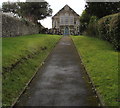
Trinity, Pontarddulais
The church is set back 55 metres from the A48 St Teilo Street. Trinity is the only English word on
the Welsh language information board, which shows EGLWYS FETHODISTAIDD (Methodist Church).
Image: © Jaggery
Taken: 14 Feb 2015
0.12 miles
6
Ordnance Survey Cut Mark
This OS cut mark can be found on the front of the Farmers Arms. It marks a point 12.849m above mean sea level.
Image: © Adrian Dust
Taken: 13 Oct 2013
0.14 miles
7
Capel Noddfa, Pontarddulais
According to the shield on the gable, this is Hermon Chapel, built in 893 for the Calvinist Methodists. Now, however, it has had a change of name and denomination and is an Independent Evangelical Baptist church and called Noddfa.
Image: © Eirian Evans
Taken: 27 May 2021
0.16 miles
8
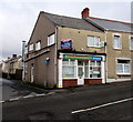
Seahorse in Pontarddulais
Chinese takeaway at 141 St Teilo Street, on the corner of Glynllwchwr Road.
The To Let board is for a ground floor flat.
Image: © Jaggery
Taken: 14 Feb 2015
0.16 miles
9
Presbyterian Church of Wales
http://www.geograph.org.uk/photo/3698517
Image: © Adrian Dust
Taken: 13 Oct 2013
0.18 miles
10
Ordnance Survey Flush Bracket (10139)
This OS Flush Bracket marks a point 16.427m above mean sea level. It can be found on the Presbyterian Church of Wales. http://www.geograph.org.uk/photo/3698562
Image: © Adrian Dust
Taken: 13 Oct 2013
0.18 miles


