IMAGES TAKEN NEAR TO
Glynhir Road, SWANSEA, SA4 8PY
Introduction
This page details the photographs taken nearby to Glynhir Road, SA4 8PY by members of the Geograph project.
The Geograph project started in 2005 with the aim of publishing, organising and preserving representative images for every square kilometre of Great Britain, Ireland and the Isle of Man.

There are currently over 7.5m images from over14,400 individuals and you can help contribute to the project by visiting https://www.geograph.org.uk
Image Map
Images are licensed for reuse under creativecommons.org/licenses/by-sa/2.0
Notes
- Clicking on the map will re-center to the selected point.
- The higher the marker number, the further away the image location is from the centre of the postcode.
Image Listing (5 Images Found)
Images are licensed for reuse under creativecommons.org/licenses/by-sa/2.0
Image
Details
Distance
1
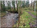
Footpath and stream at Pentrebach
The stream feeds the White Springs fishery a few hundred yards downstream.
Image: © Alan Hughes
Taken: 17 Dec 2018
0.21 miles
2

Autumn colours
The green foliage of the trees forms a striking contrast with the fallen leaves.
Image: © Alan Hughes
Taken: 17 Dec 2018
0.22 miles
3
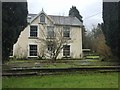
Bleak house
The grey afternoon light of early winter adds to the bleakness of this house. The footpath marked on OS maps and which appears to pass through this property is not easy to find.
Image: © Alan Hughes
Taken: 17 Dec 2018
0.23 miles
4
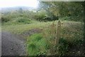
Footpath to Ebenezer Chapel
From here the right of way drops down into the trees and follows a tiny stream criss-crossing from one bank to the other across wooden footbridges.
Image: © Mama Herb
Taken: 20 Oct 2012
0.25 miles
5
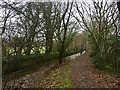
Footpath and stream
The Camffrwd, one of countless streams flowing down from the hills - here at the most south-westerly tip of the Brecon Beacons.
Image: © Alan Hughes
Taken: 17 Dec 2018
0.25 miles