IMAGES TAKEN NEAR TO
Plasgwyn Road, SWANSEA, SA4 8LZ
Introduction
This page details the photographs taken nearby to Plasgwyn Road, SA4 8LZ by members of the Geograph project.
The Geograph project started in 2005 with the aim of publishing, organising and preserving representative images for every square kilometre of Great Britain, Ireland and the Isle of Man.

There are currently over 7.5m images from over14,400 individuals and you can help contribute to the project by visiting https://www.geograph.org.uk
Image Map
Images are licensed for reuse under creativecommons.org/licenses/by-sa/2.0
Notes
- Clicking on the map will re-center to the selected point.
- The higher the marker number, the further away the image location is from the centre of the postcode.
Image Listing (38 Images Found)
Images are licensed for reuse under creativecommons.org/licenses/by-sa/2.0
Image
Details
Distance
1
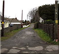
Lane NNW from Upper Mill Road, Pontarddulais
A nearby public footpath sign points this way.
Image: © Jaggery
Taken: 11 Feb 2015
0.04 miles
2
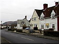
North along Glynhir Road, Pontarddulais
Looking north towards Pentrebach.
Image: © Jaggery
Taken: 11 Feb 2015
0.06 miles
3
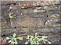
Ordnance Survey Cut Mark
This OS cut mark can be found on the wall west side of Glynhir Road. It marks a point 25.737m above mean sea level.
Image: © Adrian Dust
Taken: 29 Jan 2023
0.06 miles
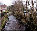
4
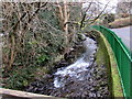
White water on the Dulais below Upper Mill Road, Pontarddulais
The stream Dulais flows west towards its confluence with the River Loughor.
Image: © Jaggery
Taken: 11 Feb 2015
0.06 miles
5
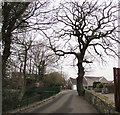
Dominant tree in a wall, Upper Mill Road, Pontarddulais
A wall has been built along an edge of the tree which dominates the view even in leafless February.
Image: © Jaggery
Taken: 11 Feb 2015
0.07 miles
6
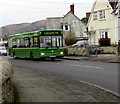
Llanelli bus in Glynhir Road, Pontarddulais
On route 400.
Image: © Jaggery
Taken: 11 Feb 2015
0.07 miles
7
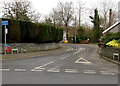
Upper Mill unsuitable for large vehicles, Pontarddulais
Viewed from Caecerrig Road. Is a large vehicle the same as a heavy goods vehicle?
Image: © Jaggery
Taken: 11 Feb 2015
0.07 miles
8
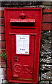
King George V postbox in a Pontarddulais wall
Located here. http://www.geograph.org.uk/photo/4346826
Image: © Jaggery
Taken: 11 Feb 2015
0.08 miles
9
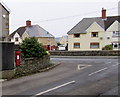
Postbox on a corner in Pontarddulais
King George V postbox http://www.geograph.org.uk/photo/4346835 in Upper Mill Road at the Caecerrig Road junction.
Image: © Jaggery
Taken: 11 Feb 2015
0.08 miles
10
West along Dulais, Pontarddulais
Dulais stream flows away from this http://www.geograph.org.uk/photo/4346049 bridge.
Image: © Jaggery
Taken: 11 Feb 2015
0.08 miles