IMAGES TAKEN NEAR TO
Pantiago Road, SWANSEA, SA4 8LU
Introduction
This page details the photographs taken nearby to Pantiago Road, SA4 8LU by members of the Geograph project.
The Geograph project started in 2005 with the aim of publishing, organising and preserving representative images for every square kilometre of Great Britain, Ireland and the Isle of Man.

There are currently over 7.5m images from over14,400 individuals and you can help contribute to the project by visiting https://www.geograph.org.uk
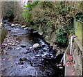
Image Map
Images are licensed for reuse under creativecommons.org/licenses/by-sa/2.0
Notes
- Clicking on the map will re-center to the selected point.
- The higher the marker number, the further away the image location is from the centre of the postcode.
Image Listing (57 Images Found)
Images are licensed for reuse under creativecommons.org/licenses/by-sa/2.0
Image
Details
Distance
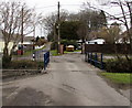
1
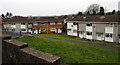
Houses in Pantiago Road, Pontarddulais
At the NE end of Pantiago Road.
Image: © Jaggery
Taken: 11 Feb 2015
0.07 miles
2
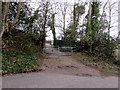
Railings across a footpath, Upper Mill, Pontarddulais
The path leads to houses in Pantiago Road and Bryniago.
Image: © Jaggery
Taken: 11 Feb 2015
0.09 miles
3
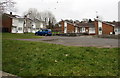
Pantiago Road houses in Pontarddulais
At the NE end of Pantiago Road.
Image: © Jaggery
Taken: 11 Feb 2015
0.09 miles
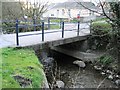
4
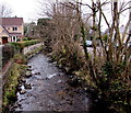
West along Dulais, Pontarddulais
Dulais stream flows away from this http://www.geograph.org.uk/photo/4346049 bridge.
Image: © Jaggery
Taken: 11 Feb 2015
0.09 miles
5
Small bridge over river Dulais
There are some very narrow lanes and back streets in this west part of Pontardulais, despite all the residences. This bridge is just about wide enough for one car at a time.
Image: © Nigel Davies
Taken: 16 Apr 2006
0.09 miles
6
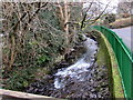
White water on the Dulais below Upper Mill Road, Pontarddulais
The stream Dulais flows west towards its confluence with the River Loughor.
Image: © Jaggery
Taken: 11 Feb 2015
0.09 miles
7
Bridge over Dulais, Pontarddulais
A minor road crosses above Dulais stream. Upper Mill Road is ahead.
Image: © Jaggery
Taken: 11 Feb 2015
0.10 miles
8
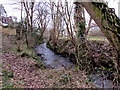
Dulais downstream from a weir, Pontarddulais
The stream flows away from this http://www.geograph.org.uk/photo/4346038 weir, towards its confluence with the River Loughor at the western edge of Pontarddulais.
Image: © Jaggery
Taken: 11 Feb 2015
0.11 miles
9
Stream height gauges, Pontarddulais
Gauging the height of Dulais, a tributary of the River Loughor.
Image: © Jaggery
Taken: 11 Feb 2015
0.12 miles
10
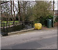
Yellow grit box and green stream monitoring station, Upper Mill Road, Pontarddulais
The monitoring station is above these gauges http://www.geograph.org.uk/photo/4346805 at the edge of the stream named Dulais.
Image: © Jaggery
Taken: 11 Feb 2015
0.12 miles