IMAGES TAKEN NEAR TO
St. Teilo Street, SWANSEA, SA4 8LQ
Introduction
This page details the photographs taken nearby to St. Teilo Street, SA4 8LQ by members of the Geograph project.
The Geograph project started in 2005 with the aim of publishing, organising and preserving representative images for every square kilometre of Great Britain, Ireland and the Isle of Man.

There are currently over 7.5m images from over14,400 individuals and you can help contribute to the project by visiting https://www.geograph.org.uk
Image Map
Images are licensed for reuse under creativecommons.org/licenses/by-sa/2.0
Notes
- Clicking on the map will re-center to the selected point.
- The higher the marker number, the further away the image location is from the centre of the postcode.
Image Listing (54 Images Found)
Images are licensed for reuse under creativecommons.org/licenses/by-sa/2.0
Image
Details
Distance
1
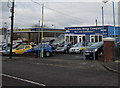
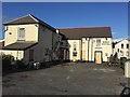
Pontardulais Motor Company in Pontarddulais
Viewed across the A48 St Teilo Street. The name sign uses the single D spelling of the town's name, an English variant of the Welsh form Pontarddulais. As anyone who has seen a Welsh language Scrabble set knows,
DD is one of several digraphs with their own tile because each digraph is one letter, not two, in Welsh orthography. For example, a word such as ffordd has to be played using only 4 tiles, including the FF tile and the DD tile. It is not allowed to use 2 F tiles or 2 D tiles for such a word.
Image: © Jaggery
Taken: 14 Feb 2015
0.01 miles
2
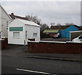
Abel Thomas & Sons in Pontarddulais
Viewed across the A48 St Teilo Street. The name on the single-storey
white building is Abel Thomas & Sons Funeral Directors
Image: © Jaggery
Taken: 14 Feb 2015
0.02 miles
3

King Fish Bar in Pontarddulais
On the NW side of the King Hotel. http://www.geograph.org.uk/photo/4348192
Image: © Jaggery
Taken: 14 Feb 2015
0.04 miles
4
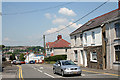
Pontarddulais: St Teilo Street
Looking west-north-west on the A48 trunk road
Image: © Martin Bodman
Taken: 8 Jun 2006
0.05 miles
5
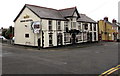
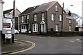
King Hotel in Pontarddulais
At 238 St Teilo Street, on the corner of Pentre Road.
Image: © Jaggery
Taken: 14 Feb 2015
0.05 miles
6
King Hotel
The King Hotel, Pontarddulais - now closed.
Image: © Alan Hughes
Taken: 5 Nov 2017
0.05 miles
7
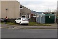
Kings Hotel electricity substation in Pontarddulais
Located in Alltiago Road near the King Hotel. http://www.geograph.org.uk/photo/4348192 The Western Power Distribution electricity substation identifier is KINGS HOTEL 52-3045. Electricity substations can be useful for research because their name usually doesn't change and so records what was nearby. In this case, it may be that the hotel was formerly named Kings Hotel, or it may be a mistake.
Image: © Jaggery
Taken: 14 Feb 2015
0.06 miles
8
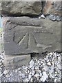
Ordnance Survey Cut Mark
This OS cut mark can be found on the roadside wall in front of No1 Bolgoed Road. It marks a point 26.939m above mean sea level.
Image: © Adrian Dust
Taken: 13 Oct 2013
0.06 miles
9
Direction signs in Pontarddulais
On the corner of Alltiago Road and the A48.
Image: © Jaggery
Taken: 14 Feb 2015
0.07 miles
10
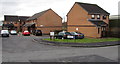
St Brides Close, Pontarddulais
On the south side of Oakfield Street.
Image: © Jaggery
Taken: 14 Feb 2015
0.08 miles