IMAGES TAKEN NEAR TO
Glynllwchwr Road, SWANSEA, SA4 8LP
Introduction
This page details the photographs taken nearby to Glynllwchwr Road, SA4 8LP by members of the Geograph project.
The Geograph project started in 2005 with the aim of publishing, organising and preserving representative images for every square kilometre of Great Britain, Ireland and the Isle of Man.

There are currently over 7.5m images from over14,400 individuals and you can help contribute to the project by visiting https://www.geograph.org.uk
Image Map
Images are licensed for reuse under creativecommons.org/licenses/by-sa/2.0
Notes
- Clicking on the map will re-center to the selected point.
- The higher the marker number, the further away the image location is from the centre of the postcode.
Image Listing (71 Images Found)
Images are licensed for reuse under creativecommons.org/licenses/by-sa/2.0
Image
Details
Distance
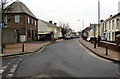
1
Glynllwchwr Road, Pontarddulais
Viewed across the A48, here named St Teilo Street.
Image: © Jaggery
Taken: 14 Feb 2015
0.02 miles
2
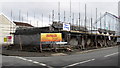
Site of the demolished Siloh chapel in Pontarddulais
In February 2015, construction work is in progress on the corner of Oakfield Street and Glynllwchwr Road.
Image: © Jaggery
Taken: 14 Feb 2015
0.02 miles
3
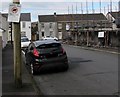
Clean it up in Pontarddulais
The notice on an Oakfield Street pole tells dog owners that they can be fined up to £1,000 if they do not clean up their dog's droppings. Scaffolding encloses construction work on the corner site formerly occupied by Siloh chapel.
Image: © Jaggery
Taken: 14 Feb 2015
0.04 miles
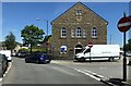
4
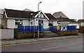
Canolfan Y Bont in Pontarddulais
Located at 28 Dulais Road, Canolfan Y Bont is an informal community skills and learning centre which became a major project for the Pontarddulais Partnership when Gorseinon College decided to close the facility in 2009. After extensive negotiations with the college the Partnership reopened this centre in August 2010.
Image: © Jaggery
Taken: 11 Feb 2015
0.07 miles
5
South along Dulais Road, Pontarddulais
Looking towards St Teilo Street.
Image: © Jaggery
Taken: 11 Feb 2015
0.07 miles
6
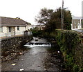
Weir across Dulais, Pontarddulais
The stream Dulais is a tributary of the River Loughor.
Image: © Jaggery
Taken: 11 Feb 2015
0.07 miles
7
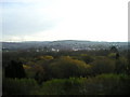
View towards Pontarddulais
A rather gloomy autumn day!
Image: © Marion Phillips
Taken: 24 Nov 2010
0.07 miles
8
Capel Noddfa, Pontarddulais
According to the shield on the gable, this is Hermon Chapel, built in 893 for the Calvinist Methodists. Now, however, it has had a change of name and denomination and is an Independent Evangelical Baptist church and called Noddfa.
Image: © Eirian Evans
Taken: 27 May 2021
0.07 miles
9
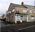
Seahorse in Pontarddulais
Chinese takeaway at 141 St Teilo Street, on the corner of Glynllwchwr Road.
The To Let board is for a ground floor flat.
Image: © Jaggery
Taken: 14 Feb 2015
0.08 miles
10

Dulais from Dulais Road, Pontarddulais
The stream Dulais is a tributary of the River Loughor.
Image: © Jaggery
Taken: 11 Feb 2015
0.08 miles