IMAGES TAKEN NEAR TO
Upper James Street, SWANSEA, SA4 8JD
Introduction
This page details the photographs taken nearby to Upper James Street, SA4 8JD by members of the Geograph project.
The Geograph project started in 2005 with the aim of publishing, organising and preserving representative images for every square kilometre of Great Britain, Ireland and the Isle of Man.

There are currently over 7.5m images from over14,400 individuals and you can help contribute to the project by visiting https://www.geograph.org.uk
Image Map (Loading...)


Getting Data...Please wait
Leaflet Map data © OpenStreetMap
Images are licensed for reuse under creativecommons.org/licenses/by-sa/2.0
Notes
- Clicking on the map will re-center to the selected point.
- The higher the marker number, the further away the image location is from the centre of the postcode.
Image Listing (63 Images Found)
Images are licensed for reuse under creativecommons.org/licenses/by-sa/2.0
Image
Details
Distance
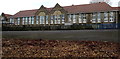
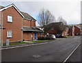
1

Vehicle entrance to Pontarddulais Primary School
From James Street Pontarddulais. All drivers must report to the site office before entry. No vehicle is allowed in during the times shown. A white arrow on a blue notice points right towards the entrance for pedestrians.
Image: © Jaggery
Taken: 14 Feb 2015
0.03 miles
2
West side of Pontarddulais Primary School
Viewed from James Street. The school site extends for 170 metres, about half of which is in view.
Image: © Jaggery
Taken: 14 Feb 2015
0.03 miles
3
Eastern end of James Street, Pontarddulais
The Pontarddulais Primary School nameboard is on the south side of the school site. http://www.geograph.org.uk/photo/4353476
Image: © Jaggery
Taken: 14 Feb 2015
0.04 miles
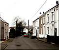
4
James Street, Pontarddulais
Looking east towards Pontarddulais Primary School.
Image: © Jaggery
Taken: 14 Feb 2015
0.06 miles
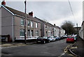
5

James Street houses in Pontarddulais
The houses face Pontarddulais Primary School. http://www.geograph.org.uk/photo/4353476
Image: © Jaggery
Taken: 14 Feb 2015
0.06 miles
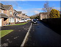
6
Goppa Road houses in Pontarddulais
Looking north.
Image: © Jaggery
Taken: 11 Feb 2015
0.11 miles
7
Clos Maes yr Ysgol, Pontarddulais
From the corner of Nant y Ffin.
Image: © Jaggery
Taken: 14 Feb 2015
0.11 miles
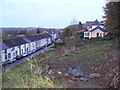
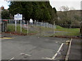
9
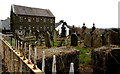
Y Gopa churchyard, Pontarddulais
On the north side of this http://www.geograph.org.uk/photo/4344604 church.
Image: © Jaggery
Taken: 11 Feb 2015
0.12 miles
10
Gorsaf y Glowr, Pontarddulais
Private road and cul-de-sac extending for 150 metres from the north side of the A48 Bolgoed Road.
Image: © Jaggery
Taken: 14 Feb 2015
0.13 miles