IMAGES TAKEN NEAR TO
Clayton Drive, SWANSEA, SA4 8AD
Introduction
This page details the photographs taken nearby to Clayton Drive, SA4 8AD by members of the Geograph project.
The Geograph project started in 2005 with the aim of publishing, organising and preserving representative images for every square kilometre of Great Britain, Ireland and the Isle of Man.

There are currently over 7.5m images from over14,400 individuals and you can help contribute to the project by visiting https://www.geograph.org.uk
Image Map
Images are licensed for reuse under creativecommons.org/licenses/by-sa/2.0
Notes
- Clicking on the map will re-center to the selected point.
- The higher the marker number, the further away the image location is from the centre of the postcode.
Image Listing (102 Images Found)
Images are licensed for reuse under creativecommons.org/licenses/by-sa/2.0
Image
Details
Distance
1
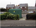
Water Street electricity substation, Pontarddulais
The Western Power Distribution electricity substation is on the north side of Water Street.
Image: © Jaggery
Taken: 11 Feb 2015
0.04 miles
2
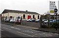
J E Jeffreys Car Sales, Pontarddulais
Dulais Garage, Water Street.
Image: © Jaggery
Taken: 11 Feb 2015
0.05 miles
3
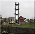
Tower and fire station, Pontarddulais
Viewed from Water Street across the stream named Dulais. Pontarddulais Fire Station is part of the Swansea Command of the Mid and West Wales Fire and Rescue Service. The station covers Pontarddulais, Pontlliw, Hendy, Llanedi, Pont Abraham and Waungron, and provides emergency cover and support for Swansea suburbs.
Image: © Jaggery
Taken: 11 Feb 2015
0.06 miles
4
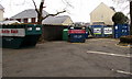
Water Street recycling area, Pontarddulais
Bottle bank on the left, newspapers & magazines in the bin next to it, various bins in the background.
Image: © Jaggery
Taken: 11 Feb 2015
0.06 miles
5
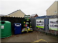
Salvation Army clothing & shoes donations bin in Pontarddulais
On the north side of Water Street, in this http://www.geograph.org.uk/photo/4372263 recycling area.
Also in view are a can bank and shoe bank.
Image: © Jaggery
Taken: 11 Feb 2015
0.06 miles
6
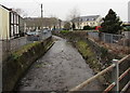
Downstream along Dulais, Pontarddulais
Dulais flows away from this http://www.geograph.org.uk/photo/4370494 bridge towards its confluence with the River Loughor about 400 metres ahead.
Image: © Jaggery
Taken: 11 Feb 2015
0.06 miles
7
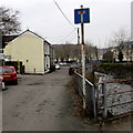
Western end of Water Street, Pontarddulais
The sign shows No Through Road. In the lower right corner, a bridge http://www.geograph.org.uk/photo/4370494 crosses over the stream Dulais.
Image: © Jaggery
Taken: 11 Feb 2015
0.06 miles
8

Water Street bridge over Dulais, Pontarddulais
The No Through Road shows that Water Street ends ahead.
The bridge spans the stream Dulais, a tributary of the River Loughor.
Image: © Jaggery
Taken: 11 Feb 2015
0.06 miles
9
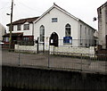
Carmel Apostolic Church in Pontarddulais
Located in Water Street, on the south bank of the stream Dulais.
Image: © Jaggery
Taken: 11 Feb 2015
0.07 miles
10

Water Street, Pontarddulais
On the south bank of a stream, Dulais, flowing below the railings.
Image: © Jaggery
Taken: 11 Feb 2015
0.07 miles