IMAGES TAKEN NEAR TO
Talsarn, LAMPETER, SA48 8RA
Introduction
This page details the photographs taken nearby to SA48 8RA by members of the Geograph project.
The Geograph project started in 2005 with the aim of publishing, organising and preserving representative images for every square kilometre of Great Britain, Ireland and the Isle of Man.

There are currently over 7.5m images from over14,400 individuals and you can help contribute to the project by visiting https://www.geograph.org.uk
Image Map
Images are licensed for reuse under creativecommons.org/licenses/by-sa/2.0
Notes
- Clicking on the map will re-center to the selected point.
- The higher the marker number, the further away the image location is from the centre of the postcode.
Image Listing (5 Images Found)
Images are licensed for reuse under creativecommons.org/licenses/by-sa/2.0
Image
Details
Distance
1
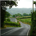
The B4337 descending to Tal-sarn in Ceredigion
The dwelling on the left is shown on maps as Penlan House.
Image: © Roger D Kidd
Taken: 23 Jul 2013
0.15 miles
2
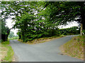
Road junction north of Tal-sarn in Ceredigion
A minor lane joins the B4337 about a mile and a half north of Tal-sarn.
Image: © Roger D Kidd
Taken: 23 Jul 2013
0.18 miles
3
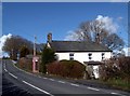
Ty-n-lon on the B4337
Noted for feeding the Red Kites which can number 30 to 40 daily.
Image: © John Fielding
Taken: 30 Mar 2008
0.20 miles
4
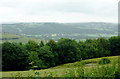
Forest and valley north of Trefilan in Ceredigion
From the lane near Penlan House, this view is south-east across the forest lining Nant Rhiwafallen towards the Afon Aeron Valley near Abermeurig.
Image: © Roger D Kidd
Taken: 23 Jul 2013
0.23 miles
5
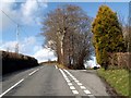
The B4337
Above Ty-n-lon, the right hand fork Arfron.
Image: © John Fielding
Taken: 30 Mar 2008
0.24 miles