IMAGES TAKEN NEAR TO
/Broderi, LAMPETER, SA48 8NX
Introduction
This page details the photographs taken nearby to /Broderi, SA48 8NX by members of the Geograph project.
The Geograph project started in 2005 with the aim of publishing, organising and preserving representative images for every square kilometre of Great Britain, Ireland and the Isle of Man.

There are currently over 7.5m images from over14,400 individuals and you can help contribute to the project by visiting https://www.geograph.org.uk
Image Map (Loading...)


Getting Data...Please wait
Leaflet Map data © OpenStreetMap
Images are licensed for reuse under creativecommons.org/licenses/by-sa/2.0
Notes
- Clicking on the map will re-center to the selected point.
- The higher the marker number, the further away the image location is from the centre of the postcode.
Image Listing (39 Images Found)
Images are licensed for reuse under creativecommons.org/licenses/by-sa/2.0
Image
Details
Distance
1
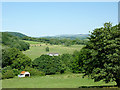
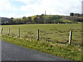
Farmland and Derry Ormond Park, Ceredigion
This telephoto assisted image is looking across the lower end of Cwm Nant Dyfel, towards (the distant) Cwm Afon Dulas. Nant Dyfel flows through the trees beyond the rusty shed.
Image: © Roger D Kidd
Taken: 22 Jul 2012
0.10 miles
2
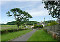
Pathway from St Bledrws Church, Ceredigion
Looking across the A485. The lane ahead leads through Derry Ormond Park and continues towards Denmark Farm.
Image: © Roger D Kidd
Taken: 23 Jul 2012
0.10 miles
3
Stone stile into churchyard, Betws Bledrws
Image: © John Lord
Taken: 6 Aug 2011
0.10 miles
4
Looking southwest from an unclassified road
Over pasture towards the Derry Ormond Tower. I am grateful to Roger Kidd for his photo of Image as it identifies the name of the tower.
Image: © John Baker
Taken: 25 Mar 2015
0.10 miles
5
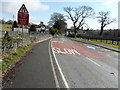
Approaching Betws Bledrws from the WSW on the A485
There is a small sign pointing to Denmark Farm Conservation Centre opposite the house at the next left turn and a similar sign at Image beside the A485.
Image: © John Baker
Taken: 25 Mar 2015
0.10 miles
7
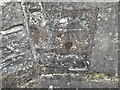
Ordnance Survey Cut Mark
This OS cut mark can be found on the SW angle of St Bledrws' Church. It marks a point 133.707m above mean sea level.
Image: © Adrian Dust
Taken: 20 Feb 2023
0.11 miles
8
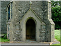
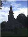
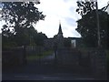
Entrance to St Bledrws Church, Ceredigion
The tower (and this doorway) were built circa 1830, though most of the main part of the church was rebuilt in 1887.
Image: © Roger D Kidd
Taken: 23 Jul 2012
0.11 miles
9
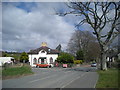
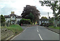
Betws Bledrws
The small village of Betws Bledrws lies three miles from Lampeter on either side of the A485. It comprises two parts: Bro Deri, a row of council houses in the north of square Image and the village proper shown here.
The white building is New Lodge, built in c.1840 to the design of Charles Cockerell, who also designed the house whose gate it guarded, Derry Ormond Park (demolished in 1953). Cockerell was also responsible for the designs of St. David's College (now the University of Wales, Lampeter) and Derry Ormond Tower.
Image: © Dan Gregory
Taken: 5 Apr 2008
0.11 miles