IMAGES TAKEN NEAR TO
Felinfach, LAMPETER, SA48 8BW
Introduction
This page details the photographs taken nearby to SA48 8BW by members of the Geograph project.
The Geograph project started in 2005 with the aim of publishing, organising and preserving representative images for every square kilometre of Great Britain, Ireland and the Isle of Man.

There are currently over 7.5m images from over14,400 individuals and you can help contribute to the project by visiting https://www.geograph.org.uk
Image Map (Loading...)


Getting Data...Please wait
Leaflet Map data © OpenStreetMap
Images are licensed for reuse under creativecommons.org/licenses/by-sa/2.0
Notes
- Clicking on the map will re-center to the selected point.
- The higher the marker number, the further away the image location is from the centre of the postcode.
Image Listing (3 Images Found)
Images are licensed for reuse under creativecommons.org/licenses/by-sa/2.0
Image
Details
Distance
1
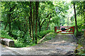
Cwm of the Nant Wysg
The stream descends quite steeply down the wooded cwm. On the right is the entrance to Cwarel-isaf, while on the other side of the stream, hidden by the trees, is the trackbed of the Lampeter, Aberayron and New Quay Light Railway, now a farm track.
Image: © Nigel Brown
Taken: 2 Jun 2008
0.05 miles
2
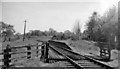
Blaenplwyf Halt (remains)
View SE, towards Lampeter. This very remote Halt on the Lampeter - Aberayron branch - Blaenplwyf is not even marked on the 1:50,000 map, was closed 12/2/51. The branch passenger service was withdrawn on 10/9/51; the goods service was cut back from Aberayron to Felin Fran on 5/4/65, finally from there as recently as 1/10/73.
Image: © Ben Brooksbank
Taken: 2 Jun 1962
0.06 miles
3
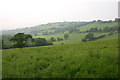
Fields near Rhiwonnen
Lying above the east side of the Nant Wysg.
Image: © Nigel Brown
Taken: 2 Jun 2008
0.23 miles