IMAGES TAKEN NEAR TO
Felinfach, LAMPETER, SA48 8AF
Introduction
This page details the photographs taken nearby to SA48 8AF by members of the Geograph project.
The Geograph project started in 2005 with the aim of publishing, organising and preserving representative images for every square kilometre of Great Britain, Ireland and the Isle of Man.

There are currently over 7.5m images from over14,400 individuals and you can help contribute to the project by visiting https://www.geograph.org.uk
Image Map (Loading...)


Getting Data...Please wait
Leaflet Map data © OpenStreetMap
Images are licensed for reuse under creativecommons.org/licenses/by-sa/2.0
Notes
- Clicking on the map will re-center to the selected point.
- The higher the marker number, the further away the image location is from the centre of the postcode.
Image Listing (4 Images Found)
Images are licensed for reuse under creativecommons.org/licenses/by-sa/2.0
Image
Details
Distance
1
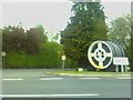
Mynedfa'r hen hufenfa Felinfach old creamery entrance
Mynedfa'r hen hufenfa
Nawr lleoliad gwaithfeydd blas fwyd,powdwr llaeth i anifeiliaid a cwmni trafnidiaeth
Old Creamery entrance
Now location of food flavourings and powdered milk for animals factories and a transportation firm
Image: © G Williams
Taken: 25 Apr 2009
0.04 miles
2

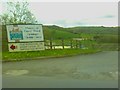
The A482 to Ystrad Aeron
Picture taken adjacent to what used to be the Creamery, as shown on the OS 199 Lampeter map. The premises now house a company called Sensient.
Image: © John Fielding
Taken: 2 Apr 2008
0.07 miles
3
Hen ffatri gaws/Old cheese factory
Yr hen ffatri gaws ar y A482. Gyda arwydd yn dangos ffordd i'r ffatrioedd arall yn yr ardal; sydd ar safle'r hen hufenfa Felinfach.
- - - - -
The old cheese factory on the A482. With sign showing way to other factories in the area; that are on the Felinfach old creamery site.
Image: © G Williams
Taken: 25 Apr 2009
0.15 miles
4
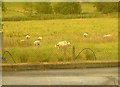
Defaid / Sheep
Defaid tu cefn i'r Hen Hufenfa
-----
Sheep behind the old Creamery
Image: © G Williams
Taken: 29 Jul 2006
0.16 miles