IMAGES TAKEN NEAR TO
Felinfach, LAMPETER, SA48 8AE
Introduction
This page details the photographs taken nearby to SA48 8AE by members of the Geograph project.
The Geograph project started in 2005 with the aim of publishing, organising and preserving representative images for every square kilometre of Great Britain, Ireland and the Isle of Man.

There are currently over 7.5m images from over14,400 individuals and you can help contribute to the project by visiting https://www.geograph.org.uk
Image Map (Loading...)


Getting Data...Please wait
Leaflet Map data © OpenStreetMap
Images are licensed for reuse under creativecommons.org/licenses/by-sa/2.0
Notes
- Clicking on the map will re-center to the selected point.
- The higher the marker number, the further away the image location is from the centre of the postcode.
Image Listing (30 Images Found)
Images are licensed for reuse under creativecommons.org/licenses/by-sa/2.0
Image
Details
Distance
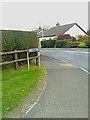
1
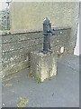
Pwmp dwr y pentre/Village water pump
Wedi ei lleoli ar palmaent wrth heol A482; yn Felinfach.
Located on footpath along the A482; at Felinfach.
Image: © G Williams
Taken: 22 Apr 2009
0.03 miles
2
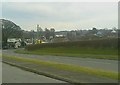
Pentre Felinfach Village
Pentre Felinfach ar y A482 o'r Neuadd Goffa
Felinfach Village on the A482 from the Memorial Hall
Image: © G Williams
Taken: 28 Feb 2009
0.03 miles
3
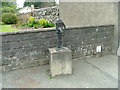
Felinfach Pump
Pump manufactured by Joseph Evans
Image: © N Scott
Taken: 1 May 2015
0.03 miles
4
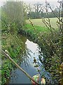
Afon Gwili river
Afon Gwili yn edrych i'r gorllewin o bont heol A482 a welwyd yn y llun yma http://www.geograph.org.uk/photo/1266841. A gyferbyn i'r llun yma yn edrych i'r Gogledd-Ddwyrain mae'r http://www.geograph.org.uk/photo/1266839 .
The river Gwili looking west off the A482 bridge seen in this http://www.geograph.org.uk/photo/1266841. And opposite this picture looking North-East is http://www.geograph.org.uk/photo/1266839
Image: © G Williams
Taken: 22 Apr 2009
0.03 miles
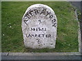
7
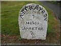
Old Milestone by the A482, Felinfach, Llanfihangel Ystrad parish
Aberayron tombstone by the A482, in parish of Llanfihangel Ystrad (Ceredigion District), Felinfach, in village centre, West side of road, North of bus shelter, and opposite the B4342 junction.
Inscription reads:-
ABERAYRON
7
MILES
LAMPETER
6
Grade II listed by Cadw.
Reference Number: 17445 https://cadwpublic-api.azurewebsites.net/reports/listedbuilding/FullReport?lang=&id=17445
Surveyed
Milestone Society National ID: CRD_AALP07
Image: © Milestone Society
Taken: Unknown
0.05 miles
8
Mynedfa i Maes y Tren / Entrance to Maes y Tren
Image: © G Williams
Taken: 22 Apr 2009
0.06 miles
9
Felinfach, Milestone - Aberayron 7 Lampeter 6
Image: © N Scott
Taken: 1 May 2015
0.06 miles
10
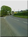
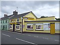
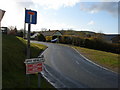
Yr A482 wrth ymyl Maes-y-tren yn edrych tua'r de-ddwyrain at y gyffordd ?'r B4342
The A482 at Maes-y-tren looking south-east onto the B4342 junction under the Felinfach primary school
The A482 by Maes-y-tren entrance looking south-east onto the B4342 junction under the Felinfach primary school (as the A482 goes out of sight).
To the right of the A482 and painted yellow you have the sub-post office-general store.
Image] to the East-South of the picture.
Further along under the tree is Image]
Yr A482 wrth ymyl Fynedfa Maes-y-tren; yn edrych De-Ddwyrain at yr cyffordd B4342 o dan ysgol gynradd Felinfach (wrth i'r A482 fynd mas o olwg).
I'r Dde a wedi ei beintio'n melyn mae'r is-swyddfa bost-stor chyffredinol.
A Image] i'r Ddwyrain-De
Draw bellach i'r Ddwyrain-De o dan y goeden mae'r mynedfa i'r Image]
Image: © G Williams
Taken: 22 Apr 2009
0.06 miles