IMAGES TAKEN NEAR TO
Ciliau Aeron, LAMPETER, SA48 7SG
Introduction
This page details the photographs taken nearby to SA48 7SG by members of the Geograph project.
The Geograph project started in 2005 with the aim of publishing, organising and preserving representative images for every square kilometre of Great Britain, Ireland and the Isle of Man.

There are currently over 7.5m images from over14,400 individuals and you can help contribute to the project by visiting https://www.geograph.org.uk
Image Map (Loading...)


Getting Data...Please wait
Leaflet Map data © OpenStreetMap
Images are licensed for reuse under creativecommons.org/licenses/by-sa/2.0
Notes
- Clicking on the map will re-center to the selected point.
- The higher the marker number, the further away the image location is from the centre of the postcode.
Image Listing (6 Images Found)
Images are licensed for reuse under creativecommons.org/licenses/by-sa/2.0
Image
Details
Distance
2
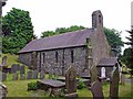
Parish Church of St Michael, Ciliau Aeron
Image: © Dylan Moore
Taken: 2 Jun 2008
0.14 miles
3
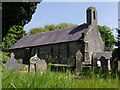
Church of St. Michael, above Ciliau Aeron
Image: © Nigel Brown
Taken: 25 May 2010
0.15 miles
4
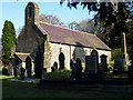
Attractive church
Beautifully detailed small church in the Aeron valley.
Image: © Neil Parker
Taken: 2 Nov 2008
0.15 miles
5
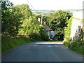
B4339 looking towards Ciliau Aeron
Looking down the hill towards Ciliau Aeron.
Image: © Nick Mutton 01329 000000
Taken: 26 Aug 2007
0.20 miles
6

B4339 - Ty Nant
Ffordd B4339 rhwng Ciliau Aeron a Dihewid / B4339 road between Ciliau Aeron and Dihewid
Image: © Ian Medcalf
Taken: 24 Dec 2008
0.21 miles