IMAGES TAKEN NEAR TO
Ciliau Aeron, LAMPETER, SA48 7PX
Introduction
This page details the photographs taken nearby to SA48 7PX by members of the Geograph project.
The Geograph project started in 2005 with the aim of publishing, organising and preserving representative images for every square kilometre of Great Britain, Ireland and the Isle of Man.

There are currently over 7.5m images from over14,400 individuals and you can help contribute to the project by visiting https://www.geograph.org.uk
Image Map
Images are licensed for reuse under creativecommons.org/licenses/by-sa/2.0
Notes
- Clicking on the map will re-center to the selected point.
- The higher the marker number, the further away the image location is from the centre of the postcode.
Image Listing (4 Images Found)
Images are licensed for reuse under creativecommons.org/licenses/by-sa/2.0
Image
Details
Distance
1
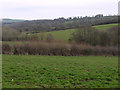
Fields near Castell Cenddu farm
Grazing land.
Image: © Nigel Brown
Taken: 14 Mar 2011
0.11 miles
3
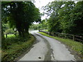
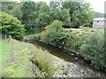
Minor road between Neuadd-lwyd and Dihewyd
Approaching a bridge over the Afon Mydr.
Image: © John Lord
Taken: 17 Aug 2018
0.22 miles