IMAGES TAKEN NEAR TO
Mill Street, LAMPETER, SA48 7HX
Introduction
This page details the photographs taken nearby to Mill Street, SA48 7HX by members of the Geograph project.
The Geograph project started in 2005 with the aim of publishing, organising and preserving representative images for every square kilometre of Great Britain, Ireland and the Isle of Man.

There are currently over 7.5m images from over14,400 individuals and you can help contribute to the project by visiting https://www.geograph.org.uk
Image Map (Loading...)


Getting Data...Please wait
Leaflet Map data © OpenStreetMap
Images are licensed for reuse under creativecommons.org/licenses/by-sa/2.0
Notes
- Clicking on the map will re-center to the selected point.
- The higher the marker number, the further away the image location is from the centre of the postcode.
Image Listing (132 Images Found)
Images are licensed for reuse under creativecommons.org/licenses/by-sa/2.0
Image
Details
Distance
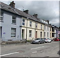
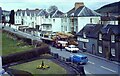
1
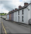
Mill Street houses, Lampeter
On the right here. https://www.geograph.org.uk/photo/6178921
Image: © Jaggery
Taken: 8 Jun 2019
0.01 miles
2
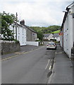
Mill Street Lampeter
On the east side of the A482 North Road.
Image: © Jaggery
Taken: 8 Jun 2019
0.02 miles
3
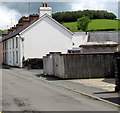
Mill Street electricity substation, Lampeter
The Western Power Distribution electricity substation is in the locked enclosure on the right.
Its identifier is MILL STREET LAMPETER 59-7268
Image: © Jaggery
Taken: 8 Jun 2019
0.04 miles
4
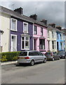
Colourful houses in Lampeter
On the north side of Station Terrace.
Image: © Jaggery
Taken: 8 Jun 2019
0.04 miles
5
North side of Station Terrace, Lampeter
Viewed in June 2019. Station Terrace is a reminder of Lampeter railway station on the Carmarthen to Aberystwyth Line. Old maps show the station beyond the eastern end of Station Terrace, out of shot on the right. As a result of floods and the Beeching Axe, the line was closed to passengers in February 1965.
Image: © Jaggery
Taken: 8 Jun 2019
0.05 miles
6
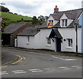
Grade II Listed Millfield Cottage, Lampeter
On the Mill Street side of the North Road corner. Cadw records that the cottage is probably 18th century, built before the 19th century expansion of Lampeter. Grade II listed in 2012 for its special architectural interest as an 18th century vernacular cottage that has survived intact. It is a building type rare in Lampeter and important as a building that predates most of the later expansion of the town.
Image: © Jaggery
Taken: 8 Jun 2019
0.05 miles
7
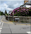
Weight limit sign on a Lampeter corner
The sign facing the A482 North Road is for Mill Street which has a 7.5 tonnes vehicle weight limit.
Image: © Jaggery
Taken: 8 Jun 2019
0.05 miles
8
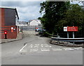
Entrance to Lampeter Delivery Office yard
Entrance to Royal Mail premises from the north side of Station Terrace.
The name sign on the right shows Lampeter Delivery Office and its Welsh equivalent.
Image: © Jaggery
Taken: 8 Jun 2019
0.05 miles
9
Timber Lorry sheding its load
Fortunately nobody was hurt.
Image: © Sandy Gerrard
Taken: Unknown
0.05 miles
10
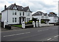
White houses, North Road, Lampeter
On the east side of the A482 North Road.
Image: © Jaggery
Taken: 8 Jun 2019
0.05 miles