IMAGES TAKEN NEAR TO
Gwel Y Creuddyn, LAMPETER, SA48 7EQ
Introduction
This page details the photographs taken nearby to Gwel Y Creuddyn, SA48 7EQ by members of the Geograph project.
The Geograph project started in 2005 with the aim of publishing, organising and preserving representative images for every square kilometre of Great Britain, Ireland and the Isle of Man.

There are currently over 7.5m images from over14,400 individuals and you can help contribute to the project by visiting https://www.geograph.org.uk
Image Map
Images are licensed for reuse under creativecommons.org/licenses/by-sa/2.0
Notes
- Clicking on the map will re-center to the selected point.
- The higher the marker number, the further away the image location is from the centre of the postcode.
Image Listing (61 Images Found)
Images are licensed for reuse under creativecommons.org/licenses/by-sa/2.0
Image
Details
Distance
1
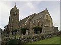
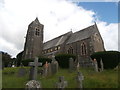
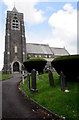
St Peter's Church
The Parish church of St. Peter was built in 1867 to the design of R. J. Withers, replacing an earlier building which in turn replaced the original St. Peter's Church. It stands on a hill near the centre of this gridsquare and is visible from much of the town below.
Image: © Dan Gregory
Taken: 20 Apr 2007
0.12 miles
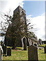
5
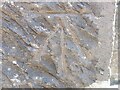
Ordnance Survey Benchmark - Lampeter, St. Peter’s Church
Ordnance Survey Benchmark (OSBM) used for levelling height above Ordnance Datum (OD).
Height (1972): 136.9200m OD (Newlyn). Mark verified by the Ordnance Survey in 1971. Description: TWR ST PETERS CH W FACE SW ANG. 0.5m above ground. 2nd Order BM.
Context: Image
Image: © N Scott
Taken: 3 Jun 2023
0.16 miles
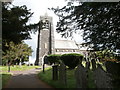
6
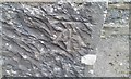
Ordnance Survey Cut Mark
This OS cut mark can be found on the west face of St Peter's Church. It marks a point 136.920m above mean sea level.
Image: © Adrian Dust
Taken: 27 Aug 2017
0.16 miles
7
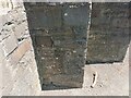
Ordnance Survey Benchmark - Lampeter, St. Peter’s Church
Ordnance Survey Benchmark (OSBM) used for levelling height above Ordnance Datum (OD).
Height (1972): 136.9200m OD (Newlyn). Mark verified by the Ordnance Survey in 1971. Description: TWR ST PETERS CH W FACE SW ANG. 0.5m above ground. 2nd Order BM.
Close-up: Image
Image: © N Scott
Taken: 3 Jun 2023
0.16 miles
8
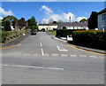
Maesyllan Ffynnonbedr, Lampeter
The road with a Welsh-only name ascends from the north side of the A475 Pontfaen Road.
Image: © Jaggery
Taken: 11 May 2019
0.16 miles
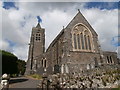
10
South side of St Peter's Church, Lampeter
St Peter's Church (Eglwys San Pedr in Welsh) is part of the Church in Wales Diocese of St Davids. Cadw records that the church was built in 1867-1870, designed by R J Withers, a London architect. It replaced the church of 1836-1838 designed by W Whittington of Neath. The building was Grade II listed in 1992 for its special architectural interest as one of the most notable High Victorian Gothic churches in West Wales. https://www.geograph.org.uk/photo/6179887 to a view of the north side.
Image: © Jaggery
Taken: 8 Jun 2019
0.17 miles