IMAGES TAKEN NEAR TO
LLANARTH, SA47 0NP
Introduction
This page details the photographs taken nearby to SA47 0NP by members of the Geograph project.
The Geograph project started in 2005 with the aim of publishing, organising and preserving representative images for every square kilometre of Great Britain, Ireland and the Isle of Man.

There are currently over 7.5m images from over14,400 individuals and you can help contribute to the project by visiting https://www.geograph.org.uk
Image Map
Images are licensed for reuse under creativecommons.org/licenses/by-sa/2.0
Notes
- Clicking on the map will re-center to the selected point.
- The higher the marker number, the further away the image location is from the centre of the postcode.
Image Listing (38 Images Found)
Images are licensed for reuse under creativecommons.org/licenses/by-sa/2.0
Image
Details
Distance
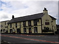
2
Llanina Arms
Llanina Arms, Llanarth, situated on the A487.
Image: © Cered
Taken: 19 Sep 2005
0.01 miles
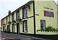
3
Alma Street (A487) in Llanart
Looking north-eastward.
Image: © Peter Wood
Taken: 2 Jun 2018
0.03 miles
4
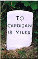
Old Milestone by the A487, Llanarth School, Llanarth parish
Cardigan low profile top by the A487, in parish of Llanarth (Ceredigion District), Llanarth, just West of Llanarth Primary School.
Inscription reads:-
TO
CARDIGAN
18 MILES
Grade II listed by Cadw.
Reference Number: 17723 https://cadwpublic-api.azurewebsites.net/reports/listedbuilding/FullReport?lang=&id=17723
Surveyed
Milestone Society National ID: CRD_CAAY18
Image: © Milestone Society
Taken: Unknown
0.04 miles
5
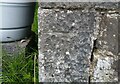
Ordnance Survey Cut Mark
This OS cut mark can be found on the old school building NE side of the road. It marks a point 117.253m above mean sea level.
Image: © Adrian Dust
Taken: 26 May 2021
0.05 miles
6
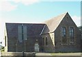
Church Hall
Church Hall belonging to St Davids Church, Llanarth. It is situated just off the A487 on the B4342.
Image: © Cered
Taken: 16 Sep 2005
0.05 miles
7
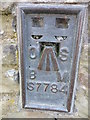
OSBM Flush Bracket S7784 - Llanarth School
Ordnance Survey Benchmark (OSBM) used for levelling height above Ordnance Datum (OD).
Height (1956): 123.9320m OD (Newlyn). Mark verified by the Ordnance Survey in 1975. Description: FL BR S7784 SCH SW SIDE RD N ANG NE FACE. 0.3m above ground. 1st Order BM.
The bracket was used on the Cardigan to Aberystwyth line (G082) of the Third Geodetic Levelling of England & Wales in 1956. Abstract G 65: http://discovery.nationalarchives.gov.uk/SearchUI/details?Uri=C11264473 [OS 54/754]
The bracket was originally used on the Aberayron to Carmarthen secondary line of the Second Geodetic Levelling of England & Wales in 1953-1954. It was levelled with a height of 406.491' above OD (Newlyn). Description: On NE face of school, Llanarth. Abstract S 7: http://discovery.nationalarchives.gov.uk/details/r/C11225155 [OS 54/639]
Close-up: Image
Image: © N Scott
Taken: 29 Mar 2016
0.05 miles
8
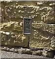
Ordnance Survey Flush Bracket (S7784)
This OS Flush Bracket can be found on the NE face of the school. It marks a point 123.952m above mean sea level.
Image: © Adrian Dust
Taken: 26 May 2021
0.05 miles
9
Ordnance Survey Flush Bracket S7784
This can be found on the wall of the school in Llanarth.
For more detail see : http://www.bench-marks.org.uk/bm261
Image: © Peter Wood
Taken: 21 Apr 2015
0.06 miles
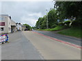
10
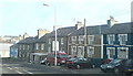
Terraced housing in Alma Street, Llanarth
On the main A487 road.
Image: © Deborah Tilley
Taken: 14 Feb 2010
0.15 miles