IMAGES TAKEN NEAR TO
Ty Myrtwydd, SWANSEA, SA4 6TG

Introduction

This page details the photographs taken nearby to Ty Myrtwydd, SA4 6TG by members of the Geograph project.

The Geograph project started in 2005 with the aim of publishing, organising and preserving representative images for every square kilometre of Great Britain, Ireland and the Isle of Man.

There are currently over 7.5m images from over14,400 individuals and you can help contribute to the project by visiting https://www.geograph.org.uk

Image Map


Images are licensed for reuse under creativecommons.org/licenses/by-sa/2.0
Notes
  • Clicking on the map will re-center to the selected point.
  • The higher the marker number, the further away the image location is from the centre of the postcode.

Image Listing (30 Images Found)

Images are licensed for reuse under creativecommons.org/licenses/by-sa/2.0
  • ...
Image
Details
Distance
1
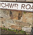
Ordnance Survey Cut Mark
This OS cut mark can be found at the junction of Culfor Road & Brynllwchwr Road. It marks a point 14.606m above mean sea level.
Image: © Adrian Dust Taken: 11 Feb 2022
0.05 miles
2
Loughor Casllwchwr looking towards the A4240
Image: © Wesley Trevor Johnston Taken: 6 Sep 2007
0.07 miles
3
Culfor Road
Terraced houses inCulfor Road, Loughor.
Image: © Alan Hughes Taken: 21 May 2019
0.09 miles
4
New housing development at Loughor
Image: © Eirian Evans Taken: 22 May 2022
0.09 miles
5
Leucarum Court path
A tarmacked alley leading from Leucarum Court, Loughor to part of the Welsh Coast Path. This part of the Welsh Coast Path is tarmacked and runs parallel to the A484 for roughly 300m. The dog bin in the photo is only 5m from the A484.
Image: © Emma M Baker Taken: 10 Aug 2021
0.10 miles
6
Welsh Coast Path, Loughor
A view of part of the Welsh Coast Path. This part is a dual-use path designed for both pedestrians and cyclists. It runs parallel to the A484 with only a very narrow strip of woodland separating them.
Image: © Emma M Baker Taken: 10 Aug 2021
0.12 miles
7
Culfor Road
Houses in Culfor road, Loughor.
Image: © Alan Hughes Taken: 21 May 2019
0.13 miles
8
Rustic gazebo at a house in Cae Castell
Wales Coast Path running alongside the garden fence
Image: © Eirian Evans Taken: 22 May 2022
0.14 miles
9
The Wales Coast Path passing Loughor
Not the most scenic part of the route, sandwiched between a housing estate and the A484.
Image: © Bill Boaden Taken: 6 Apr 2016
0.16 miles
10
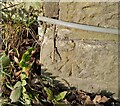
Ordnance Survey Rivet
This OS rivet can be found on the Sw angle of the railway bridge. It marks a point 6.014m above mean sea level.
Image: © Adrian Dust Taken: 11 Feb 2022
0.17 miles
  • ...