IMAGES TAKEN NEAR TO
Banfield Terrace, SWANSEA, SA4 6TF
Introduction
This page details the photographs taken nearby to Banfield Terrace, SA4 6TF by members of the Geograph project.
The Geograph project started in 2005 with the aim of publishing, organising and preserving representative images for every square kilometre of Great Britain, Ireland and the Isle of Man.

There are currently over 7.5m images from over14,400 individuals and you can help contribute to the project by visiting https://www.geograph.org.uk
Image Map
Images are licensed for reuse under creativecommons.org/licenses/by-sa/2.0
Notes
- Clicking on the map will re-center to the selected point.
- The higher the marker number, the further away the image location is from the centre of the postcode.
Image Listing (15 Images Found)
Images are licensed for reuse under creativecommons.org/licenses/by-sa/2.0
Image
Details
Distance
1
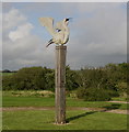
Wooden sculpture in the Loughor Foreshore park
The sculpture depicts a little egret.
Image: © john bristow
Taken: 2 Sep 2012
0.15 miles
2
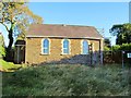
Pisgah Chapel near Loughor
Pisgah is a historic chapel where Evan Roberts first began preaching at the start of the Welsh Revival. It has attracted visitors from all over the world.
The huge tie bars in the picture hint that the building is in need of renovation. Indeed it is now claimed that it is too costly to maintain. Planning permission has been sought to demolish it and build dwellings in its place.
Story: http://www.walesonline.co.uk/news/wales-news/2012/10/17/chapel-at-heart-of-welsh-religious-revival-could-be-demolished-91466-32051859/
Image: © Nigel Davies
Taken: 21 Oct 2012
0.15 miles
3
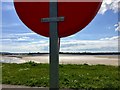
Life belt at Loughor estuary
The life belt serves two functions: the one is to save lives, the other is to shield the camera lens from direct sunlight.
Image: © Alan Hughes
Taken: 21 May 2019
0.17 miles
4
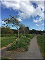
Hawthorn trees
Young hawthorn trees, shaped by the prevailing wind.
Image: © Alan Hughes
Taken: 21 May 2019
0.19 miles
5
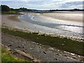
Loughor estuary
Muddy shoreline of the Loughor estuary. The road bridge carrying the A484 can be seen in the distance.
Image: © Alan Hughes
Taken: 21 May 2019
0.19 miles
6
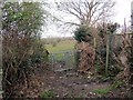
Llwybr Casllwchwr / Loughor Path
Gât fochyn ar lwybr cyhoeddus yng Nghasllwchwr sy'n cysylltu Heol Borough â Heol Gwynfa.
A kissing gate on a path in Loughor which links Borough Road with Gwynfe Road.
Image: © Alan Richards
Taken: 19 Mar 2014
0.20 miles
7
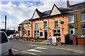
The Reverend James, Loughor
Brain's brewery has adopted this former Baptist minister as a name of some of its beers, but here they have a pub named after him too.
Image: © Bill Boaden
Taken: 6 Apr 2016
0.21 miles
8
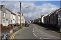
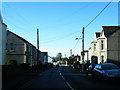
Borough Road, Loughor
Climbing away from the river in the direction of Gorseinon.
Image: © Bill Boaden
Taken: 6 Apr 2016
0.21 miles
10

Panoramic view of the Loughor estuary
The panoramic view exaggerates the curve of the River Loughor.
Image: © Alan Hughes
Taken: 21 May 2019
0.21 miles