IMAGES TAKEN NEAR TO
Glanymor Road, SWANSEA, SA4 6SA
Introduction
This page details the photographs taken nearby to Glanymor Road, SA4 6SA by members of the Geograph project.
The Geograph project started in 2005 with the aim of publishing, organising and preserving representative images for every square kilometre of Great Britain, Ireland and the Isle of Man.

There are currently over 7.5m images from over14,400 individuals and you can help contribute to the project by visiting https://www.geograph.org.uk
Image Map (Loading...)


Getting Data...Please wait
Leaflet Map data © OpenStreetMap
Images are licensed for reuse under creativecommons.org/licenses/by-sa/2.0
Notes
- Clicking on the map will re-center to the selected point.
- The higher the marker number, the further away the image location is from the centre of the postcode.
Image Listing (30 Images Found)
Images are licensed for reuse under creativecommons.org/licenses/by-sa/2.0
Image
Details
Distance
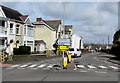
1

Ordnance Survey Cut Mark
This OS cut mark can be found on the wall of No175 Glanymor Road. It marks a point 14.655m above mean sea level.
Image: © Adrian Dust
Taken: 15 Jul 2021
0.04 miles
2
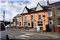
The Reverend James, Loughor
Brain's brewery has adopted this former Baptist minister as a name of some of its beers, but here they have a pub named after him too.
Image: © Bill Boaden
Taken: 6 Apr 2016
0.06 miles
4
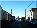
Borough Road, Loughor
Climbing away from the river in the direction of Gorseinon.
Image: © Bill Boaden
Taken: 6 Apr 2016
0.09 miles
5
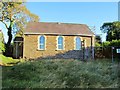
Pisgah Chapel near Loughor
Pisgah is a historic chapel where Evan Roberts first began preaching at the start of the Welsh Revival. It has attracted visitors from all over the world.
The huge tie bars in the picture hint that the building is in need of renovation. Indeed it is now claimed that it is too costly to maintain. Planning permission has been sought to demolish it and build dwellings in its place.
Story: http://www.walesonline.co.uk/news/wales-news/2012/10/17/chapel-at-heart-of-welsh-religious-revival-could-be-demolished-91466-32051859/
Image: © Nigel Davies
Taken: 21 Oct 2012
0.11 miles
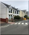
6
Zebra crossing, Corporation Road, Loughor
Across the southern end of Corporation Road which is part of the A4240.
Image: © Jaggery
Taken: 25 Mar 2016
0.13 miles
7
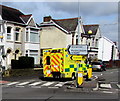
Yellow ambulance in Loughor
On the A4240 Corporation Road.
Image: © Jaggery
Taken: 25 Mar 2016
0.14 miles
8
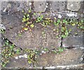
Ordnance Survey Cut Mark
This OS cut mark can be found on the wall at the junction of Glebe Road & Corporation Road. It marks a point 21.138m above mean sea level.
Image: © Adrian Dust
Taken: 15 Jul 2021
0.14 miles
9
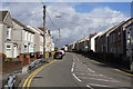
Semi-detached houses
On Corporation Road, Loughor
Image: © Eirian Evans
Taken: 22 May 2022
0.15 miles
10
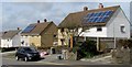
Roof solar panels, Loughor
On Glebe Road houses near the Brynllwchwr Road junction.
Image: © Jaggery
Taken: 25 Mar 2016
0.15 miles