IMAGES TAKEN NEAR TO
Belgrave Road, SWANSEA, SA4 6RB
Introduction
This page details the photographs taken nearby to Belgrave Road, SA4 6RB by members of the Geograph project.
The Geograph project started in 2005 with the aim of publishing, organising and preserving representative images for every square kilometre of Great Britain, Ireland and the Isle of Man.

There are currently over 7.5m images from over14,400 individuals and you can help contribute to the project by visiting https://www.geograph.org.uk
Image Map (Loading...)


Getting Data...Please wait
Leaflet Map data © OpenStreetMap
Images are licensed for reuse under creativecommons.org/licenses/by-sa/2.0
Notes
- Clicking on the map will re-center to the selected point.
- The higher the marker number, the further away the image location is from the centre of the postcode.
Image Listing (12 Images Found)
Images are licensed for reuse under creativecommons.org/licenses/by-sa/2.0
Image
Details
Distance
1
Queen's Avenue, Kingsbridge
Viewed across West Street. Queen's Avenue leads to the east side
of Pontybrenin Primary School which is located in Glyn Rhosyn, Gorseinon.
Image: © Jaggery
Taken: 29 Sep 2013
0.13 miles
2
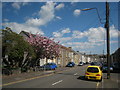
Gorseinon
Edrych tua Abertawe.
Looking towards Swansea.
Image: © Gerallt Pennant
Taken: 18 Apr 2007
0.18 miles
3
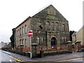
Capel y Trefnyddion Libanus Methodist Chapel
Cangen o Foriah, Casllwchwr, adeiladwyd y capel cyntaf ryw dri chanllath i fwrdd yn 1890 gyda 75 o aelodau. Ond gyda chynnydd yn y nifer o'r bobogaeth yng Nghorseion death y tŷ cwrdd yn rhy fach o lawer ac felly adeildawyd y capel presennol ar yr hewl fawr yn 1901. Yn anffodus, yn sgil prinder aelodau caewyd y capel yn 2005. Un person adnabyddus a addolai yn Libanus oedd Aneirin Talfan Davies (1909-1980), bardd, llenor, a darlledwr.
A branch of Moriah, Loughor, the first Libanus Chapel (trans. Lebanon)-located approximately 300 yards away from the present building - was built in 1890 with 75 members. But with the growth in the population of Gorseinon the meeting house became far too small and the present chapel was built in 1901. Sadly, due to dwindling numbers the chapel closed in 2005. A well known person who worshipped at Libanus was Aneirin Talfan Davies, poet, writer, and broadcaster.
Image: © Alan Richards
Taken: 1 Feb 2014
0.19 miles
4
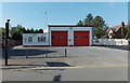
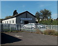
Gorseinon Fire Station
Located on the west side of West Street, a few metres on the Kingsbridge side of the southern boundary of Gorseinon. Part of the Swansea Command of the Mid and West Wales Fire and Rescue Service, this station serves Gorseinon, Loughor, Gowerton, Penclawdd and Penllergaer.
Image: © Jaggery
Taken: 29 Sep 2013
0.19 miles
5
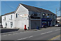
Former Kingsbridge post office
Viewed across West Street near the southern edge of Gorseinon. A postbox remains outside the corner shop, formerly Kingsbridge Newsagents and post office. Its later uses include a fireworks shop and now (September 2013) Westend Hair Unisex Salon. West End Stores are next door.
Image: © Jaggery
Taken: 29 Sep 2013
0.19 miles
6
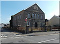
Boarded-up former Libanus chapel in Kingsbridge
Located on the corner of Libanus Road and West Street near the southern edge of Gorseinon.
The year on the date stone is 1901. The chapel closed down in c2005.
Image: © Jaggery
Taken: 29 Sep 2013
0.21 miles
7
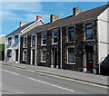
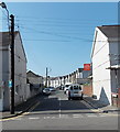
Row of 4 houses, West Street, Kingsbridge
Located near the southern edge of Gorseinon.
Image: © Jaggery
Taken: 29 Sep 2013
0.22 miles
8
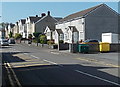
Dyffryn Road, Gorseinon
Viewed from the West Street end.
Image: © Jaggery
Taken: 29 Sep 2013
0.23 miles
9
West Street Christian Centre, Gorseinon
Set back 20 metres from the west side of West Street.
Image: © Jaggery
Taken: 29 Sep 2013
0.23 miles
10
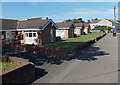
Maes Yr Efail bungalows, Kingsbridge
Viewed across West Street near the southern edge of Gorseinon.
Image: © Jaggery
Taken: 29 Sep 2013
0.24 miles