IMAGES TAKEN NEAR TO
Heol Cae Globe, SWANSEA, SA4 6QJ
Introduction
This page details the photographs taken nearby to Heol Cae Globe, SA4 6QJ by members of the Geograph project.
The Geograph project started in 2005 with the aim of publishing, organising and preserving representative images for every square kilometre of Great Britain, Ireland and the Isle of Man.

There are currently over 7.5m images from over14,400 individuals and you can help contribute to the project by visiting https://www.geograph.org.uk
Image Map (Loading...)


Getting Data...Please wait
Leaflet Map data © OpenStreetMap
Images are licensed for reuse under creativecommons.org/licenses/by-sa/2.0
Notes
- Clicking on the map will re-center to the selected point.
- The higher the marker number, the further away the image location is from the centre of the postcode.
Image Listing (41 Images Found)
Images are licensed for reuse under creativecommons.org/licenses/by-sa/2.0
Image
Details
Distance
1
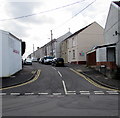
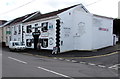
Greenfield Place, Loughor
Viewed across the B4620 Glebe Road. The Globe Inn http://www.geograph.org.uk/photo/4877988 is on the left.
Image: © Jaggery
Taken: 25 Mar 2016
0.05 miles
2
Cut Above in Loughor
Hair & beauty salon at 65 Glebe Road.
Image: © Jaggery
Taken: 25 Mar 2016
0.06 miles
3
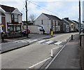
Zebra crossing, Glebe Road, Loughor
Cut Above hair & beauty salon http://www.geograph.org.uk/photo/4877916 on the left is at 65 Glebe Road.
Image: © Jaggery
Taken: 25 Mar 2016
0.07 miles
4
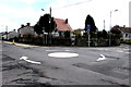
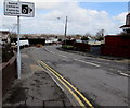
Mini-roundabout and BT phonebox in Loughor
Viewed from the southern end of Bryn Road looking towards a BT phonebox at the northern end of Waun Road.
Image: © Jaggery
Taken: 25 Mar 2016
0.07 miles
5
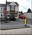
Globe Inn, Loughor
Pub at 83-85 Glebe Road, on the corner of Greenfield Place.
Image: © Jaggery
Taken: 25 Mar 2016
0.07 miles
6
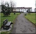
Park benches, Loughor
Alongside the path through a small park between Woodlands Road and Glebe Road (ahead).
Image: © Jaggery
Taken: 25 Mar 2016
0.08 miles
7
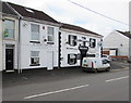
Globe Inn, Loughor
Pub at 83-85 Glebe Road, on the corner of Greenfield Place.
Image: © Jaggery
Taken: 25 Mar 2016
0.08 miles
8
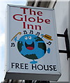
Globe Inn name sign, Loughor
Attached to a wall bracket here. http://www.geograph.org.uk/photo/4877988
Image: © Jaggery
Taken: 25 Mar 2016
0.08 miles
9
Speed cameras/ Camer?u cyflymder sign, Bryn Road, Loughor
The bilingual (English/Welsh) sign is at the southern end of Bryn Road, facing this http://www.geograph.org.uk/photo/5029963 mini-roundabout.
Image: © Jaggery
Taken: 25 Mar 2016
0.08 miles
10
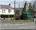
Electricity substation on a Loughor corner
The dark green cabinet is a Western Power Distribution electricity substation on the corner of Glebe Road and Woodlands Road.
Image: © Jaggery
Taken: 25 Mar 2016
0.10 miles