IMAGES TAKEN NEAR TO
Maes Yr Haf Place, SWANSEA, SA4 6PP
Introduction
This page details the photographs taken nearby to Maes Yr Haf Place, SA4 6PP by members of the Geograph project.
The Geograph project started in 2005 with the aim of publishing, organising and preserving representative images for every square kilometre of Great Britain, Ireland and the Isle of Man.

There are currently over 7.5m images from over14,400 individuals and you can help contribute to the project by visiting https://www.geograph.org.uk
Image Map (Loading...)


Getting Data...Please wait
Leaflet Map data © OpenStreetMap
Images are licensed for reuse under creativecommons.org/licenses/by-sa/2.0
Notes
- Clicking on the map will re-center to the selected point.
- The higher the marker number, the further away the image location is from the centre of the postcode.
Image Listing (48 Images Found)
Images are licensed for reuse under creativecommons.org/licenses/by-sa/2.0
Image
Details
Distance
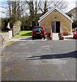
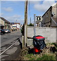
1
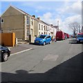
Maesyrhaf Place, Loughor
Dead-end street extending for 100 metres from the east side of Bryn Road.
Image: © Jaggery
Taken: 25 Mar 2016
0.02 miles
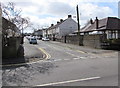
2
Belgrave Road, Loughor
Viewed across Bryn Road from the corner of Woodland Road.
The black arrow on the sign on the right points along Belgrave Road towards Gower College Swansea.
Image: © Jaggery
Taken: 25 Mar 2016
0.08 miles
3
Telecoms cabinets on a Loughor corner
On the corner of Belgrave Road and Bryn Road, opposite Woodlands Road.
Image: © Jaggery
Taken: 25 Mar 2016
0.08 miles
4
Danybryn Road, Loughor
On the south side of Alexandra Road.
Image: © Jaggery
Taken: 25 Mar 2016
0.09 miles
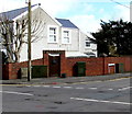
5
Bryn Hall Evangelical Church, Loughor
Set back 30 metres from the east side of Bryn Road.
Image: © Jaggery
Taken: 25 Mar 2016
0.09 miles
6
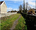
Public footpath towards Danybryn Road, Loughor
From the east side of Bryn Road. Bryn Hall Evangelical Church http://www.geograph.org.uk/photo/5029835 is on the right.
Image: © Jaggery
Taken: 25 Mar 2016
0.10 miles
7
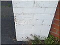
Ordnance Survey Cut Mark
This OS cut mark can be found on the gatepost of No2 Belgrave Road. It marks a point 41.401m above mean sea level.
Image: © Adrian Dust
Taken: 15 Jul 2021
0.10 miles
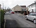
8
Pengry Road, Loughor
Viewed across Bryn Road from the Maesyrhaf Place junction.
Image: © Jaggery
Taken: 25 Mar 2016
0.10 miles
9
Public footpath sign, Bryn Road, Loughor
Pointing along this http://www.geograph.org.uk/photo/5029870 path to Danybryn Road.
Image: © Jaggery
Taken: 25 Mar 2016
0.10 miles
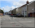
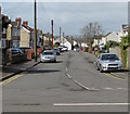
10
Woodlands Road, Loughor
On the west side of Bryn Road.
Image: © Jaggery
Taken: 25 Mar 2016
0.12 miles