IMAGES TAKEN NEAR TO
Greenland Terrace, ABERAERON, SA46 0ER
Introduction
This page details the photographs taken nearby to Greenland Terrace, SA46 0ER by members of the Geograph project.
The Geograph project started in 2005 with the aim of publishing, organising and preserving representative images for every square kilometre of Great Britain, Ireland and the Isle of Man.

There are currently over 7.5m images from over14,400 individuals and you can help contribute to the project by visiting https://www.geograph.org.uk
Image Map
Images are licensed for reuse under creativecommons.org/licenses/by-sa/2.0
Notes
- Clicking on the map will re-center to the selected point.
- The higher the marker number, the further away the image location is from the centre of the postcode.
Image Listing (395 Images Found)
Images are licensed for reuse under creativecommons.org/licenses/by-sa/2.0
Image
Details
Distance
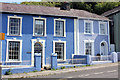
1
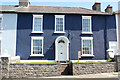
Ty-Rhos 5 Greenland Terrace
Grade II Listed house.
Image: © Jo and Steve Turner
Taken: 29 Jun 2011
0.00 miles
3
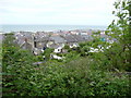
Some of the back gardens of Aberaeron
The back gardens of Aberaeron present as pleasant an aspect as the frontages, with nice extensions and outside spaces. I always think that you get a good appreciation of a town or city when entering it on a train, as you get to see into and over back gardens and the rear elevations of houses - sometimes in contrast to their street frontages. You can get the same insight from walking on foot.
Image: © Jeremy Bolwell
Taken: 12 May 2011
0.02 miles
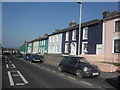
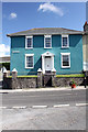
5
10 and 11 Greenland Terrace
Two Grade II Listed houses.
Image: © Jo and Steve Turner
Taken: 29 Jun 2011
0.03 miles
6
1 Greenland Terrace
Early 19th century Grade II Listed house.
Image: © Jo and Steve Turner
Taken: 29 Jun 2011
0.03 miles
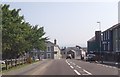
7
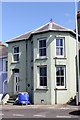
Westgate Toll House 12 Greenland Terrace
One of the few houses that don't seem to be listed on Greenland Terrace it was the last of the three Aberaeron toll houses to be built in about 1813.
Image: © Jo and Steve Turner
Taken: 29 Jun 2011
0.03 miles
8
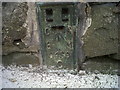
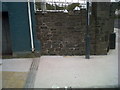
OSBM Flush Bracket S0456 - Aberaeron, Panteg Rd
Ordnance Survey Benchmark (OSBM) used for levelling height above Ordnance Datum (OD).
Height (1956): 17.4087m OD (Newlyn). Mark verified by the Ordnance Survey in 1975. Description: FL BR S0456 HO S SIDE RD JUNC N ANG NE FACE. 0.3m above ground. 1st Order BM.
The bracket was used on the Cardigan to Aberystwyth line (G082) of the Third Geodetic Levelling of England & Wales in 1956. It was levelled with a height of 57.157' above OD (Newlyn). Description: NE face of stone wall, 1' NW from N angle of house, SW side of road. Abstract G 65: http://discovery.nationalarchives.gov.uk/SearchUI/details?Uri=C11264473 [OS 54/754]
The bracket was previously used on the Aberystwyth to Lampeter secondary line of the Second Geodetic Levelling of England & Wales in 1942. It was levelled with a height of 57.195' above OD (Newlyn). Description: On wall at N angle of house, SW side of road. Abstract A 483: http://discovery.nationalarchives.gov.uk/details/r/C11178827 [OS 54/148] It was originally levelled at 57.25' above OD (Newlyn) on the Aberaeron to Carmarthen secondary line in 1927-1928. Abstract A 471: http://discovery.nationalarchives.gov.uk/details/r/C11178815 [OS 54/136]
Context: Image
Image: © N Scott
Taken: 23 May 2012
0.03 miles
9
OSBM Flush Bracket S0456 - Aberaeron, Panteg Rd
Ordnance Survey Benchmark (OSBM) used for levelling height above Ordnance Datum (OD).
Height (1956): 17.4087m OD (Newlyn). Mark verified by the Ordnance Survey in 1975. Description: FL BR S0456 HO S SIDE RD JUNC N ANG NE FACE. 0.3m above ground. 1st Order BM.
The bracket was used on the Cardigan to Aberystwyth line (G082) of the Third Geodetic Levelling of England & Wales in 1956. It was levelled with a height of 57.157' above OD (Newlyn). Description: NE face of stone wall, 1' NW from N angle of house, SW side of road. Abstract G 65: http://discovery.nationalarchives.gov.uk/SearchUI/details?Uri=C11264473 [OS 54/754]
The bracket was previously used on the Aberystwyth to Lampeter secondary line of the Second Geodetic Levelling of England & Wales in 1942. It was levelled with a height of 57.195' above OD (Newlyn). Description: On wall at N angle of house, SW side of road. Abstract A 483: http://discovery.nationalarchives.gov.uk/details/r/C11178827 [OS 54/148] It was originally levelled at 57.25' above OD (Newlyn) on the Aberaeron to Carmarthen secondary line in 1927-1928. Abstract A 471: http://discovery.nationalarchives.gov.uk/details/r/C11178815 [OS 54/136]
Close-up: Image
Image: © N Scott
Taken: 23 May 2012
0.03 miles
10
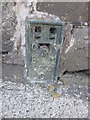
Ordnance Survey Flush Bracket (S0456)
This OS Flush Bracket can be found on the south side of the road junction, NE face. It marks a point 17.409m above mean sea level.
Image: © Adrian Dust
Taken: 19 Sep 2015
0.03 miles