IMAGES TAKEN NEAR TO
Harbour Lane, ABERAERON, SA46 0BA
Introduction
This page details the photographs taken nearby to Harbour Lane, SA46 0BA by members of the Geograph project.
The Geograph project started in 2005 with the aim of publishing, organising and preserving representative images for every square kilometre of Great Britain, Ireland and the Isle of Man.

There are currently over 7.5m images from over14,400 individuals and you can help contribute to the project by visiting https://www.geograph.org.uk
Image Map (Loading...)


Getting Data...Please wait
Leaflet Map data © OpenStreetMap
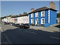
Images are licensed for reuse under creativecommons.org/licenses/by-sa/2.0
Notes
- Clicking on the map will re-center to the selected point.
- The higher the marker number, the further away the image location is from the centre of the postcode.
Image Listing (482 Images Found)
Images are licensed for reuse under creativecommons.org/licenses/by-sa/2.0
Image
Details
Distance
1
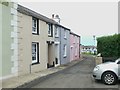
Harbour Lane, Aberaeron
On the west side of the harbour
Image: © Eirian Evans
Taken: 24 Jun 2011
0.00 miles
2
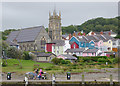
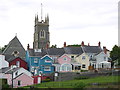
Housing and church in Aberaeron, Ceredigion
A telephoto image obtained looking across the marina and river towards Holy Trinity Church.
Image: © Roger D Kidd
Taken: 14 Aug 2015
0.01 miles
3
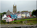
Housing and church tower in Aberaeron, Ceredigion
This is a telephot assisted image looking over the harbour towards the back of houses, very colourfully maintained in Stryd y Bont (Bridge Street) and the tower of Holy Trinity Church.
Image: © Roger D Kidd
Taken: 14 Aug 2015
0.01 miles
4
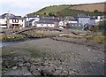
Footbridge, Aberaeron
Not easy to see, but the bridge deck goes through the arch of the bridge rather than being on top of it. Note how the town is enclosed by steep hills.
Image: © Humphrey Bolton
Taken: 30 Sep 2007
0.01 miles
5
Aberaeron Church
The church sits on Bridge St just to the east of Lower Bridge where the A487 crosses the River Aeron. The coloured houses sit on the same road opposite the church with a splendid view from their rear windows of Aberaeron Harbour
Image: © Nigel Mykura
Taken: 1 Jul 2015
0.01 miles
6
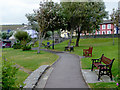
Footpath in Aberaeron, Ceredigion
South-east of the harbour, looking towards Stryd y Bont (Bridge Street).
Image: © Roger D Kidd
Taken: 14 Aug 2015
0.01 miles
7
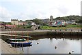
Harbour area, Aberaeron
Towards Holy Trinity Church.
My wife remarked on how many of the properties had been painted that it resembled a mini Tobermory.
Image: © Richard Hoare
Taken: 6 Sep 2017
0.01 miles
8
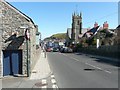
Looking east-northeast along the A487
With Holy Trinity church on the right side of the road.
Image: © John Baker
Taken: 21 Mar 2015
0.02 miles
9
Houses in Aberaeron
Houses on the main road the A487 passing through Aberaeron.
Image: © Philip Halling
Taken: 16 Jul 2021
0.02 miles
10
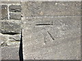
Ordnance Survey Cut Mark
This can be found on the wall of Holy Trinity Church in Aberaeron.
For more detail see : http://www.bench-marks.org.uk/bm43166
Image: © Peter Wood
Taken: 21 Apr 2015
0.02 miles