IMAGES TAKEN NEAR TO
Maenygroes, NEW QUAY, SA45 9TS
Introduction
This page details the photographs taken nearby to SA45 9TS by members of the Geograph project.
The Geograph project started in 2005 with the aim of publishing, organising and preserving representative images for every square kilometre of Great Britain, Ireland and the Isle of Man.

There are currently over 7.5m images from over14,400 individuals and you can help contribute to the project by visiting https://www.geograph.org.uk
Image Map (Loading...)


Getting Data...Please wait
Leaflet Map data © OpenStreetMap
Images are licensed for reuse under creativecommons.org/licenses/by-sa/2.0
Notes
- Clicking on the map will re-center to the selected point.
- The higher the marker number, the further away the image location is from the centre of the postcode.
Image Listing (1 Images Found)
Images are licensed for reuse under creativecommons.org/licenses/by-sa/2.0
Image
Details
Distance
1
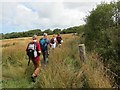
Llwybr Ceffyl Ty'r Ffynnon Bridleway
Cerddwyr yn rhodio ar hyd llwybr ceffyl sy'n cystlltu Ffarm Ty'r Ffynnon a Thy Rhos.
Walkers proceeding along a bridleway linking Ty'r Ffynnon Farm (trans. well house) with Ty'r Rhos (trans. moor house)
Image: © Alan Richards
Taken: 18 Aug 2013
0.13 miles