IMAGES TAKEN NEAR TO
/Bro Gido, NEW QUAY, SA45 9SR
Introduction
This page details the photographs taken nearby to /Bro Gido, SA45 9SR by members of the Geograph project.
The Geograph project started in 2005 with the aim of publishing, organising and preserving representative images for every square kilometre of Great Britain, Ireland and the Isle of Man.

There are currently over 7.5m images from over14,400 individuals and you can help contribute to the project by visiting https://www.geograph.org.uk
Image Map
Images are licensed for reuse under creativecommons.org/licenses/by-sa/2.0
Notes
- Clicking on the map will re-center to the selected point.
- The higher the marker number, the further away the image location is from the centre of the postcode.
Image Listing (11 Images Found)
Images are licensed for reuse under creativecommons.org/licenses/by-sa/2.0
Image
Details
Distance
1
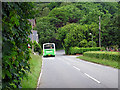
A TrawsCymru bus leaving Gilfachreda
On the T5 service from Aberystwyth to Cardigan via New Quay.
Image: © John Lucas
Taken: 17 Jun 2016
0.03 miles
2
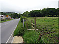
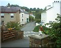
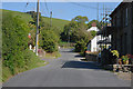
The B4342 running through Gilfachreda
The road from New Quay to Llanarth. The footpath to the right leads to a scenic path through Cwm Gido.
Image: © John Lucas
Taken: 17 Jun 2016
0.03 miles
4
In the village of Gilfachreda
On the road to Cei-bach.
Image: © John Lucas
Taken: 17 Jun 2016
0.08 miles
6
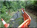
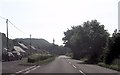
Road Subsidence
This road appears to be sliding down the hill.
Image: © Sandy Gerrard
Taken: 12 Sep 2022
0.11 miles
8
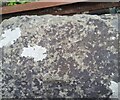
Ordnance Survey Cut Mark
This OS cut mark can be found on the wall of Capel Wern. It marks a point 50.710m above mean sea level.
Image: © Adrian Dust
Taken: 1 Jul 2021
0.15 miles
9
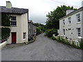
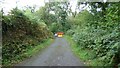
The road through Llaingarreglwyd
Passing some of the houses in the small community.
Image: © Nigel Brown
Taken: 9 Sep 2010
0.21 miles
10
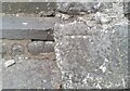
Ordnance Survey Rivet
This OS rivet can be found on the west parapet of the bridge. It marks a point 25.743m above mean sea level.
Image: © Adrian Dust
Taken: 1 Jul 2021
0.24 miles