IMAGES TAKEN NEAR TO
Maenygroes, NEW QUAY, SA45 9RH
Introduction
This page details the photographs taken nearby to SA45 9RH by members of the Geograph project.
The Geograph project started in 2005 with the aim of publishing, organising and preserving representative images for every square kilometre of Great Britain, Ireland and the Isle of Man.

There are currently over 7.5m images from over14,400 individuals and you can help contribute to the project by visiting https://www.geograph.org.uk
Image Map (Loading...)


Getting Data...Please wait
Leaflet Map data © OpenStreetMap
Images are licensed for reuse under creativecommons.org/licenses/by-sa/2.0
Notes
- Clicking on the map will re-center to the selected point.
- The higher the marker number, the further away the image location is from the centre of the postcode.
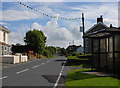
Image Listing (6 Images Found)
Images are licensed for reuse under creativecommons.org/licenses/by-sa/2.0
Image
Details
Distance
1
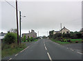
A486 approaches crossroads in Maen-y-groes
Image: © Stuart Logan
Taken: 8 Oct 2011
0.05 miles
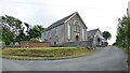
3

Maenygroes Chapel
Maenygroes Congregational Chapel, Llanllwchaearn just off the A486 in Maen-y-groes.
Image: © Cered
Taken: 20 Sep 2005
0.12 miles

6
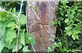
Ordnance Survey Cut Mark
This OS cut mark can be found on the gatepost at the road junction. It marks a point 129.128m above mean sea level.
Image: © Adrian Dust
Taken: 26 May 2021
0.22 miles