IMAGES TAKEN NEAR TO
South John Street, NEW QUAY, SA45 9NG
Introduction
This page details the photographs taken nearby to South John Street, SA45 9NG by members of the Geograph project.
The Geograph project started in 2005 with the aim of publishing, organising and preserving representative images for every square kilometre of Great Britain, Ireland and the Isle of Man.

There are currently over 7.5m images from over14,400 individuals and you can help contribute to the project by visiting https://www.geograph.org.uk
Image Map (Loading...)


Getting Data...Please wait
Leaflet Map data © OpenStreetMap
Images are licensed for reuse under creativecommons.org/licenses/by-sa/2.0
Notes
- Clicking on the map will re-center to the selected point.
- The higher the marker number, the further away the image location is from the centre of the postcode.
Image Listing (626 Images Found)
Images are licensed for reuse under creativecommons.org/licenses/by-sa/2.0
Image
Details
Distance
1
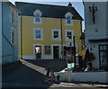
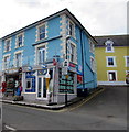
The Hungry Trout
The 'Hungry Trout' Restaurant has now closed down and is for sale and has a fine view over Cardigan Bay. It used to be the post office where Dylan Thomas posted his scripts to London.
Image: © Richard Hoare
Taken: 20 Jan 2019
0.01 miles
2
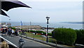
View to the harbour wall in New Quay / Ceinewydd, Ceredigion
A compact and pretty town and harbour. Well worth an explore, even when crowded.
Image: © Jeremy Bolwell
Taken: 26 Jul 2014
0.01 miles
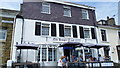
3
Former Hungry Trout restaurant, New Quay
A Purple Bricks SOLD board is outside the former restaurant in early July 2018.
The blue plaque on the wall on the left is Dylan Thomas Trail marker 4.
This building used to be the post office where Dylan Thomas posted his scripts to London.
Image: © Jaggery
Taken: 4 Jul 2018
0.01 miles
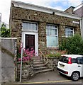
4
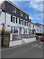
Ocean Blue in New Quay
South John Street shop selling gifts, ice cream etc.
Image: © Jaggery
Taken: 4 Jul 2018
0.01 miles
5

Fair Winds and Following Seas
This sculpture was unveiled on 10 June 2019 and is entitled 'Fair Winds and Following Seas'. The sculpture marks the mid-point on the Wales Coast Path; a long distance path of 870 miles which follows the entire Welsh coast.
Image: © Philip Halling
Taken: 16 Jul 2021
0.01 miles
6
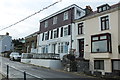
Restaurant and cafe in New Quay / Ceinewydd, Ceredigion
A lovely licensed restaurant and cafe overlooking the harbour in the town - ideal for our needs today. The town is crammed with fish and chip shop restaurants but we wanted bara brith, coffee and a nice view - hard to improve on this! Great service and value too. Sorry, I'm sounding like a dreaded Trip Adviser review!
Image: © Jeremy Bolwell
Taken: 26 Jul 2014
0.01 miles
7
Bilingual street name sign Stryd Ioan/South John Street on a stone building, New Quay
The Welsh and English names are not exact equivalents - Stryd Ioan is Welsh for John Street.
This is one of many Welsh/English street name non-equivalents in New Quay.
Image: © Jaggery
Taken: 4 Jul 2018
0.01 miles
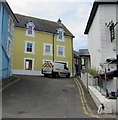
8
From Glanmor Terrace to South John Street, New Quay
The B4342 Glanmor Terrace on the camera side becomes the B4342 South John Street ahead.
The bilingual name sign on the left shows that Glanmor Terrace is Rhes Glanmor in Welsh.
Image: © Jaggery
Taken: 4 Jul 2018
0.02 miles
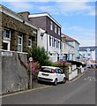
9
Penwig Lane, New Quay
Ascending from South John Street towards Spring Gardens.
Double yellow lines on both sides indicate no parking at any time.
Image: © Jaggery
Taken: 4 Jul 2018
0.02 miles