IMAGES TAKEN NEAR TO
Grovesend, SWANSEA, SA4 4WQ
Introduction
This page details the photographs taken nearby to SA4 4WQ by members of the Geograph project.
The Geograph project started in 2005 with the aim of publishing, organising and preserving representative images for every square kilometre of Great Britain, Ireland and the Isle of Man.

There are currently over 7.5m images from over14,400 individuals and you can help contribute to the project by visiting https://www.geograph.org.uk
Image Map
Images are licensed for reuse under creativecommons.org/licenses/by-sa/2.0
Notes
- Clicking on the map will re-center to the selected point.
- The higher the marker number, the further away the image location is from the centre of the postcode.
Image Listing (14 Images Found)
Images are licensed for reuse under creativecommons.org/licenses/by-sa/2.0
Image
Details
Distance
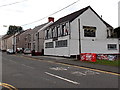
1
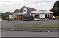
Grovesend Sports and Social Club
Located in Plas Road, near the corner of Plas Newydd in Grovesend.
Image: © Jaggery
Taken: 29 Sep 2013
0.03 miles
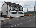
2
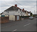
Plas Road houses, Grovesend
Viewed from the corner of the B4296.
Image: © Jaggery
Taken: 29 Sep 2013
0.05 miles
3
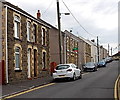
New Road Grovesend
Looking SE from High Street.
Image: © Jaggery
Taken: 29 Sep 2013
0.10 miles
4
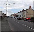
Coalbrook Road, Grovesend
Looking along the B4296 Coalbrook Road towards High Street.
Image: © Jaggery
Taken: 29 Sep 2013
0.12 miles
5
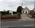
Mount Pleasant Church, Grovesend
Viewed across High Street. The name stone shows the year 1908.
Image: © Jaggery
Taken: 29 Sep 2013
0.14 miles
6
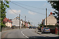
Grovesend: housing on the B4296
Looking north on the Gowerton – Pontarddulais road
Image: © Martin Bodman
Taken: 8 Jun 2006
0.19 miles
7
Bryn Lliw Grovesend
Viewed from the corner of New Road. Bryn Lliw is a bar and restaurant at 6 High Street, Grovesend.
Image: © Jaggery
Taken: 29 Sep 2013
0.20 miles
8
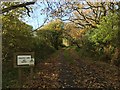
Private lane
Private lane leading to Pengelly.
Image: © Alan Hughes
Taken: 5 Nov 2017
0.21 miles
9
Bryn Lliw viewed from the south, Grovesend
Bryn Lliw is a bar and restaurant at 6 High Street, Grovesend.
Image: © Jaggery
Taken: 29 Sep 2013
0.22 miles
10
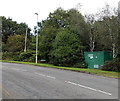
Gas governor alongside Coalbrook Road, Grovesend
The green box is a gas governor, which controls the amount of gas
that passes through and its pressure, ensuring both are at optimal levels.
Image: © Jaggery
Taken: 29 Sep 2013
0.22 miles